Daily prices p.p. incl. VAT.
01 May - 15 October
4 hrs. total time, depending on requirements with stopover
From 12 years, minimum height 160 cm
Weather-independent with good clothing
Participants
4 to 9 participants per guide. Bookable for individuals and groups
Issue bikes, adjustment to body size and weight
Break as needed and stop for refreshments if necessary
Experience the beauty of the Bavarian Alps on our e-bike tour Lenggries!
We start in Lenggries in the Sport-Piraten camp and cycle on varied paths through our beautiful home with breathtaking views of the surrounding mountains and valleys. The route selection is individually chosen on site by our guide and is tailored to the wishes and riding ability of our guests. This tour is therefore also ideal for e-bike novices who want a relaxing ride through nature.
Before you set off, our guide will explain to you how the e-bike works and how to operate it correctly. Also during the ride you will get useful tips on riding technique to master the trails safely and adapted to your riding ability!
During our e-bike tour Lenggries we also take small breaks as needed to enjoy the idyllic atmosphere. Here you can also take a small snack with you or we stop if necessary in a cozy pub that we pass along the way. The picturesque landscape of forests and mountains also offers some great photo opportunities.
In addition to the e-bike, we will also provide you with a helmet and a drinks bottle. Please remember to bring your own sneakers and clothing suitable for the weather, as well as a small backpack for snacks, etc. If you have cycling gloves, padded cycling shorts and cycling glasses, we recommend that you bring these as well.
Book your e-bike tour now Lenggries and experience the beauty of the Bavarian Alps in a unique way!
- Guided e-bike tour Lenggries
- Supervision by bike guide
- Equipment: e-bike, helmet, drink bottle
- Total duration approx. 4.0 hrs.
- lots of fun
Participation requirements
- Minimum age 12 years, minimum height 160 cm
- Persons under 18 years of age only in the company of a parent or guardian or with a written declaration of consent. DOWNLOAD
- normal physical condition, no heart or cardiovascular problems
- max. permissible body weight = 130kg
- For safety reasons, persons under the influence of alcohol are not allowed to participate in the e-bike tour Lenggries !
What you should bring
- closed sports shoes
- small backpack for snack, change of clothes
- Functional clothing adapted to the weather
- Sports glasses
- Cycling gloves as required
Additional information
- The e-bike tour Lenggries will take place if the minimum number of participants is 4. Otherwise, an alternative date must be agreed.
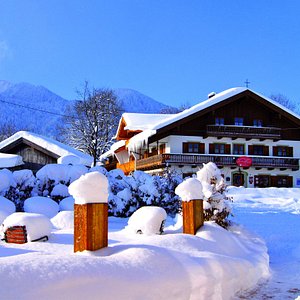
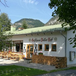
Sport-Piraten Camp, Isarstraße 2, 83661 Lenggries
Sure! Please contact us and we will take care of your non-binding reservation until 2 weeks before the date.
Approximately 90-95% of the tours take place as planned.
Your safety has absolute priority. Sometimes it is only possible to predict at very short notice (1 to 2 days) before the tour whether the circumstances are suitable for the tour. As soon as we are sure whether the tour can take place (or not), we will let you know!
No, the tickets and vouchers remain valid. In case of cancellation an alternative date will be arranged.
Yes! As long as you book under the same name, you will be assigned to the same group.
For bookings with different names, feel free to let us know.
There is a maximum of 9 participants per guide. If we have several groups for the same time, the guides decide on the spot whether the groups go together or separately.
The minimum number of participants is 4.
The meeting point is our camp in Lenggries. There you will be greeted and given your equipment. The start of the e-mountain bike tour is not far away. If you have special tour wishes, the journey may have to be planned.
Valuables can be locked in your own car or in our camp.
1 rating for E-bike tour Lenggries
Based on 1 rating(s)
Rated by 01 Customers

Christian Kinzler
Placeholder for ratings...
What is your feedback on the tour? Cancel answers
Your email address will not be published.
You might also like this ...
E-mountain bike tour + workshop, isar rafting bavaria, e-bike tour lenggries.
from 69,00 €
number of persons - +
Times are in Europe/Berlin
- Choose a date for available start times.
- Partially available
Data protection overview
Mountainbiken in Lenggries
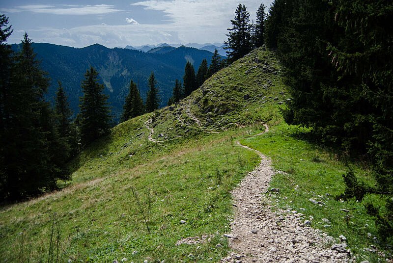
Lenggries hat viele tolle Trails zu bieten
Enge Kurven, nie enden wollende Wurzelteppiche und ein verdientes Bier auf der Hütte. Im nur ca. eine Autostunde südlich von München liegende Lenggries erwartet dich all das und gehört deshalb zu einem meiner top Ausgangspunkte für Bike-Touren im bayerischen Alpenvorland.
Inhaltsverzeichnis
Unterkünfte, mtb touren bei lenggries.
Im sogenannten Isarwinkel zwischen Karwendel und Wettersteingebirge finden Mountainbiker Abwechslung pur. Der Sylvensteinsee und die Isar laden nicht nur zum Baden, sondern auch zu gemütlichen Cross Country Touren ein.

Viele MTB Touren führen entlang der jungen Isar
Wer mehr Bock auf Action hat, findet im Bikepark Lenggries am Brauneck jede Menge Trails in allen Schwierigkeitsgraden.
Aber nicht nur im Bikepark hat die Region um Lenggries zahlreiche spannende Singletrails zu bieten. So gehören die Trails am Geierstein mit endlosen Wurzelpassagen und steilen Kurven zu meinen absoluten Favoriten in der Gegend.
Wer mit der BOB unterwegs ist, hat auch die Option von Lenggries bis an den Tegernsee zu fahren und auf dem Weg zahlreiche Trails zu surfen.
Eine Hütteneinkehr gehört für viele Mountainbiker einfach dazu. Eine Auswahl an Hütten in der Region Lenggries findest du hier:
Für eine kurze Feierabendrunde bietet sich die Auffahrt zur Lenggrieser Hütte an. Hier ist nicht nur das Panorama ein Genuss, sondern auch die einheimische Küche.

Der Buchstein im Rücken der Tegernseer Hütte
Die Tegernseer Hütte ist zwar nicht direkt mit dem Mountainbike erreichbar, wegen der tollen Lage lohnt sich eine Hike & Bike Tour dorthin allemal.

Die Aueralm
Zwischen Lenggries und dem Tegernsee liegt die Aueralm . Sie kann beispielsweise bei einer Tour vom Tegernsee nach Lenggries besucht werden. Der Singletrail von der Aueralm durch das Steinbachtal gehört zu einem der beliebtesten der Region.
Zur Tour: Vom Tegernsee nach Lenggries
Wer nicht auf einer der zahlreichen Hütten übernachten möchte, findet in Lenggries auch ausreichend Hotels und Ferienwohnungen:
Booking.com
Von München aus ist Lenggries mit der Bayerischen Oberland Bahn (BOB) in ca. Einer Stunde erreichbar. Sie fährt stündlich vom Münchner HBF bis zur Endstation Lenggries. Fahrräder können mitgeführt werden.
Mit dem Auto geht es entweder über die A8 der die A95 ebenfalls in etwa einer Stunde. An Sommerwochenenden ist die Staugefahr auf diesen Strecken jedoch hoch.
Zwiesel Trail: abwechslungsreiche Feierabendtour von Bad Tölz

Weiterlesen
Mit dem Mountainbike durchs Eschenlainetal nach Lenggries

Mountainbike Tour auf die Lenggrieser Hütte

Benediktenwand Umrundung

MTB-Touren am Rechelkopf: Umrundung und Trail-Abfahrt vom Gipfel

MTB Trailrunde: Fockenstein & Geierstein
MTB Tour von der Jachenau zum Sylvensteinspeicher

MTB-Tour von Lenggries über’s Seekarkreuz nach Tegernsee

Hike & Bike: Roßstein und Tegernseer Hütte

- Chismar, Steve (Autor)
Hat dir der Beitrag gefallen?
Keine Werbung, nur Infos über neue Beiträge!
- Bitte nimm beim Befahren des Trails Rücksicht auf Wanderer. Share the Trail!
- Für die Korrektheit und Aktualität der GPS-Tracks kann keine Garantie übernommen werden. Du fährst du die Tour auf eigene Gefahr!
- Prüfe vor dem Fahren, ob die Daten korrekt sind und ob die Strecke deinen Fähigkeiten entspricht! Verlasse dich nicht auf meine subjektive Einschätzung.
Dir hat die Tour gefallen? Dann spendier’ mir doch einen Kaffee und unterstütze dieses Projekt ☕️
Sieh dir jetzt weitere Mountainbike Touren an:
- Wettersteinrunde mit dem Mountainbike
- Aussichtsreiche Bike & Hike Tour zum Blaser-Gipfel
- Lenzerheide: Biketicket 2 RIDE (rot) von Chur
- Jägers Notweg Trail & Klebe Alm Trail: Enduro Tour in Sölden
- MTB Rundtour zum Älplisee Trail von Arosa
Folge uns bei Social Media:

Datenschutzeinstellungen
Wir nutzen Cookies auf unserer Website. Einige von ihnen sind essenziell, während andere uns helfen, diese Website und Ihre Erfahrung zu verbessern.
- Statistiken
- Externe Medien
Alle akzeptieren
Nur essenzielle Cookies akzeptieren
Individuelle Datenschutzeinstellungen
Cookie-Details Datenschutzerklärung Impressum
Hier finden Sie eine Übersicht über alle verwendeten Cookies. Sie können Ihre Einwilligung zu ganzen Kategorien geben oder sich weitere Informationen anzeigen lassen und so nur bestimmte Cookies auswählen.
Alle akzeptieren Speichern
Zurück Nur essenzielle Cookies akzeptieren
Essenziell (2)
Essenzielle Cookies ermöglichen grundlegende Funktionen und sind für die einwandfreie Funktion der Website erforderlich.
Cookie-Informationen anzeigen Cookie-Informationen ausblenden
Statistiken (2)
Statistik Cookies erfassen Informationen anonym. Diese Informationen helfen uns zu verstehen, wie unsere Besucher unsere Website nutzen.
Marketing (1)
Marketing Cookies werden von Drittanbietern oder Publishern verwendet, um personalisierte Werbung anzuzeigen. Sie tun dies, indem sie Besucher über Websites hinweg verfolgen.
Externe Medien (2)
Inhalte von Videoplattformen und Social Media Plattformen werden standardmäßig blockiert. Wenn Cookies von externen Medien akzeptiert werden, bedarf der Zugriff auf diese Inhalte keiner manuellen Zustimmung mehr.
Datenschutzerklärung Impressum
- Route Finder
- Route Planner
- Travel Guide
- Places to visit
- Eat & drink
- Accommodation
- Ski resorts
- Current Conditions
- Avalanche Report
- Collections
- Travel Stories
- Publications
Mountain biking trails in Lenggries
Bavaria,Germany

- Show images Hide images
The 10 most beautiful mountain biking trails in Lenggries

Discover many more routes in the Route Finder
Try planning your own routes
- Everything in Cycling
- Bike Riding
- Mountain Biking
- Road Cycling
- Bicycle Touring
Forecast for Lenggries
Find mountain biking trails in neighboring regions, similar activities in lenggries.
Localization
- +49 (0) 173 566 41 22
- [email protected]
BIKEPARK LENGGRIES
...ride on and feel the flow..., alle infos zu unseren preisen, öffnungs-zeiten, verleih bikes und protektoren, find yor trail and feel the flow.
Vom Einsteiger bis zum fortgeschrittenen Biker, wird jeder seine Lieblingsline finden. Schöne Anlieger, flowige Jumps und Drop- und Gapjumps lassen jedes Bikerherz höher schlagen.
PIx and Videos
Copyright © 2023 Bikepark Lenggries. All rights reserved.
- +49 173 566 41 22
- 83661 Lenggries
Eröffnung bei trockener Witterung am Samstag 13.04.2024!! Aktueller Status folgt an jeden Öffnungstag bis 8 Uhr in der Früh!
Explore Lenggries

Plan Your Trip to Lenggries: Best of Lenggries Tourism
Essential lenggries.
Lenggries Is Great For
Ski & ride.
Eat & drink
- Lenggrieser Bergcamping
- Arabella Brauneck Hotel
- Hotel Jager von Fall
- Gasthof Pension Neuwirt
- Gasthaus Post Vorderriß
- Eireiners Restaurant
- Die Schweizer Wirtin
- Gasthof Altwirt
- Dorfschanke Lenggries
- Zum Papyrer
- Brauneck Bergbahn
- Hochseilgarten IsarWinkel
- Naturfreibad Lenggries
- Lenggries Hütte
- Pfarrkirche St. Jakob
- Rafting on the Isar
- Beginners canyoning tour
- E mountain bike tour
- Tandem paragliding at Brauneck
- Tubing on the Isar
Lenggries / Germany

Lenggries Bike Park in Germany is just south of Munich and offers great freeride and downhill mountain bike trails right on the edge of the Alps.
- 19. Juli 2020
- 23 Min. Lesezeit
The Transalpine Adventure Part 1 - Mountain Biking from Lenggries to Passo Stelvio
Aktualisiert: 25. Mai 2021
The First Day
You can download the GPS Track here

On the twenty-fifth of June this year, I set out on a cycling trip that undoubtedly overshadows everything I had attempted on a bike before. Just to give you some reference to this story: In May I had bought my first ever mountain bike. I had been a roadie up to that point, but after crashing and wrecking my race bike, I decided to try mountain biking. I bought a 29er Hardtail, the “Count Solo” from the German bike manufacturer ROSE. It seemed sufficient for what I was planning at the time, namely just riding with some friends on our local trails in Munich.
Well, I progressed quickly, and as the lockdown eased off, I went with my buddy Clemens for a more extended tour to some trails at the Walchensee. Well and afterwards we decided on a whim to cross the Alps on our Mountain Bikes, as soon as the Corvid-19 situation would permit us. Well and this is how I had ended up here, on the twenty-fifth of June, five-thirty in the morning and cycling towards the Munich train station. And cycling on the same 29er Hardtail, because I had decided to try it against all advice on the bike I felt most comfortable on with my limited skills.

And actually, the bike held up really well, despite going well beyond what any of its designers had probably intended. It was not even the first bike on this tour to require a repair. That honour goes to the five-year-old full suspension bike Clemens had chosen for the ride. Just the evening prior he had gotten some oil on his brake pads and disk, so while sitting in the early morning train towards the town of Lenggries, we were busy cleaning up his breaks with some sandpaper. We concluded our repairs in time and left the train station in Lenggries with two working bikes, although Clemens brakes would be squealing the entire day due to the sandpaper's different patterns on the pads and the disk.
From Lenggries we first cycled upstream on the “Isarradweg” a long-distance cycleway running from the Isar river's springs in the mountains to the point where the river joins the Danube. But we did not stay on this path for long. After crossing the Isar, we made a right turn towards the Jachenau and Walchensee . The cycleway here is completely topped with asphalt, build directly next to the road and allows for smooth riding on a soft uphill. However, both the smooth-riding and the soft uphill came to an end, when we reached the town of Wieden . After a left turn, crossing the local river, we found ourselves on a gravel-surfaced forest road, climbing quite steeply towards the Rißscharte. It also started to rain softly, just a little drizzle, acting as a coolant while climbing up to the tour's first mountain-pass.

Upon reaching the pass, we got a spectacular view. We had spent the way up on forest roads surrounded by, well, trees so thick we could barely see anything of our path. We even had to push our bikes through a green tunnel created over our trail by dense shrubbery. But then the greens stepped away and suddenly revealed a view of the giant gravel pan below, created by the dry Rißbach , a small Alpine river that is pent up behind a hydropower dam way upstream, its entire water diverted to the Walchensee. Well, what is left at this stage is the empty gravel delta of the river, situated like streaks of grey paint between green hills on either side. This view presented itself to us precisely as we crossed the Rißscharte and started our descend. But we did not ride far downhill. Some thoughtful individual had put a bench here on the mountain, just in the perfect spot to have a little break and enjoy the view. The rain had stopped at this point, so we took the opportunity to enjoy a tasty power gel. Well enjoy is maybe not the right word, but at that time I was not as sick of them as I am now, after eating nothing but power gels and some packaged salted nuts for lunch ten days straight.
After our break, we went to the first single trail of the tour, and straight away found ourselves a little outmatched. The trail was steep, narrow, with sharp turns. These turns required the ability to move your back wheel while stationary with the front rim. And neither of us knew how to do that. Well and added on to that was a precipice always looming directly to the side of the trail. Any mistakes would inevitably lead to us tumbling down an almost vertical mountainside. So we took it slow, dismounted frequently and tried to move our back wheel over only on those turns we felt comfortable taking a fall on. And actually due to the sheer frequency this move was required the whole thing was quite an efficient training session. Before we had arrived at Vorderriß, Clemens had already gotten the hang of it. I was still struggling, since my frame was somewhat longer and my wheels larger (he uses a 26er) but never the less we arrived at the bottom of the valley with only two minor crashes, both our bodies intact and our spirits high. After crossing the Isar river again, we had a somewhat unique experience, cycling through the dried-up river bed of the Rißbach. It worked quite well in some places, but in others, we had to dismount again and push as the gravel was so loose we got no traction on the wheels. Anyways, after arriving on the other side, it was time for another steep forest road, this time climbing towards the Soiernlakes.
The monotony of grinding up those roads only got disrupted once, when the gravel road deteriorated into narrow singletrack. This so-called Soiernweg is quite popular with mountain bikers, although most ride it downhill not the other way round. However, it is possible in both directions, so we got some more trail kilometres under our wheels. At one section the mountainside had crashed down on the path, requiring us to dismount and push our bikes again for a few meters, but soon afterwards we reached another forest road in perfect condition. However, the friendly and easy ways concluded once we had reached the end of the forest road, located at the auxiliary cable lift up to the Soiernhaus . From here on out riding was no longer possible. We had about three kilometres and five-hundred meters of elevation gain in front of us, which would have been an easy enough hike, were it not for those bikes we had to somehow bring up with us.
We got some strange looks, and some funny comments from the hikers passing us by, while we struggled to part push and part carry our bikes up this steep hiking trail. The path is actually beautiful, passing up the mountain next to a huge waterfall. Still, we had no eye for the landscape, partly because we were busy muttering curses under our breath, partly because sweat was dripping into them.
Halfway up we had reached the Soiernlakes and took a short break on a freshwater fountain. The second half up to the so-called Jägersruh (Literally: Hunters Rest) was even more difficult. The path rose steeper and steeper, being in some places covered with large boulders, or thick loose gravel. We actually started to worry. If the descend on the other side would be of a corresponding character, we would probably have to carry down the path, as we could not imagine riding such a thing. Now is probably a good a time as any to admit, that we did not know one part of our planned route, and we had created it by loosely connecting some sections marked as a highlight on Komoot. Well, the other side of the mountain was marked as a highlight, and we stayed hopeful.

As it turns out, we were right to do so. The trail descending from the Jägersruh towards Mittenwald was the first highlight out of many to come. Sloping gently down, and running along the mountainside, it is well-maintained singletrack that is just so fun to ride. While the difficulties never rose beyond my comfort level, in the first section, and the stunning scenery is truly breathtaking, the trail is nevertheless not without its pitfalls. And that I mean in the most literal sense. The path, barely wider than your wheel in places, leaves little room for error, as just to your left-hand side is an abyss. The steep mountainside drops multiple hundred meters, almost vertical. And due to the height, the mountainside consists mostly of rocks, with some small patches of grass in between. Even the slowest of falls would lead to severe injuries here. And while riding this path at speed, time and again there are large loose rocks, that can catapult your wheels left and right if hit at the wrong angle, and in fact multiple times I had to catch my front wheel after a sudden jerk had it hurling towards the edge.
But the biggest scare I received a little later. My wheel got turned in to the side by an unfortunate rock. The speed was to low to go over the bars, so I just stopped and was standing there graciously and stationary on my no longer moving pedals. Well only for a few milliseconds until I realised I was slowly falling to the left. I put my feet on the ground, but momentum had already gotten the better of me. It would not be a far fall, but with the bike between my legs making all attempts to roll it of fruitless and the rocks on the mountainside, I was already preparing for a painful experience. At last minute I grabbed by reflex after the shrubbery growing on my right. On the first attempt, the branches I had gotten broke, but I got a hold of it on the second try and stopped myself from tumbling down the mountainside head first.
The scariest thing about this was that it had happened in complete silence. The three or four seconds it took from starting to fall to turning it into a very ungracious dismount I was too terrified to produce any sounds. Just a few meters in front of me, my buddy would not have realised the situation until I would have been way down the mountainside. Anyways after this experience, we took it a little slower.
The trail soon required another short uphill portage, but after that, it was only downhill. Also, the character changed. The path was now filled with more technical and steeper rock sections, but the difficulty increased the mountainside smoothed off, making a fall less consequential. We finally could relax a little, and even got some small jumps in on the last section of trail, but we also realised that we were physically spent. At this point, we had been on the road for longer than nine hours, with only a few gels and some salted nuts and our bodies energy reserves were drained. So we were actually quite happy once we had reached a forest road leading us down the mountain, even though we could not descend all those had worked for meters of elevation on a trail. Even as we discussed the lack of trail, shortly before reaching Mittenwald, we found one more path, quite easy compared to everything we had ridden this day, but we took it as a sweet dessert to our first day.
Upon arriving in Mittenwald, we went more or less directly to our hotel, took a shower and ate dinner. I was walking funny because my legs were so strained, and Clemens had a bad case of the saddle sores, but after all, we were happy to be on the road and looking forward to our next day.
The Second Day
Our first day had started with sunshine and blue skies. Our second day started with thunderstorms. While riding, again along the Isar Long-Distance Cycleway , we could hear thunder cracking over our heads. And this was not even the largest source of discomfort for us. Those honours were occupied by the relentless rains drenching us, despite our rain gear. After passing the town of Scharnitz , the weather slowly improved, causing us to stop and get out of our jackets. But all hopes happened to be in vain. Just as we had reached our next town of Seefeld , the rain started again. From here on out it was uphill still towards the village of Mösern and even though we had barely 1200 m of elevation we were basically able to touch the clouds with our hands, so close they passed over our heads. In Mösern it was time for the first trail of our tour. We had not previously planned to take this one because I could not identify promising singletrack on Komoot during my preparation.

But once we passed the trailhead, we immediately realised that we had found a good one just by chance. This path followed the St. Jakobs Long-Distance Hiking Trail . For this reason, I would like to caution you about this trail, as it is likely swarmed with hikers on sunnier days. And since the entire thing is mainly a hiking trail, I would like to urge you: be kind and careful with the hikers, solely in the interest of Mountain bikers' public image. The trail on its own, however, was great fun. An entirely flowy affair, leading us down towards the Inn River without a single section to difficult and necessitating us to dismount. The whole thing was just the experience we needed as an ego-boost after the long and arduous carry sections of the previous day.

Arriving at the bottom of the valley, we stumbled upon a truly magical break spot, with some small benches next to a tiny waterfall. The whole thing seemed right out of a fantasy novel, but we continued without much of a break because the weather was still overcast. Shortly afterwards we arrived in the town of Telfs , where we promptly went for the next supermarket. I had prepacked all the energy gels, energy bars, and snacks I intended to need for the entire ten days. Clemens had taken the smarter approach and only brought some more unusual items like energy gels. So I waited outside the store, while he was stocking up on sweets and snacks for the next few days. So I was the only one to get first glimpses of the summer sun, shyly peeking out between the clouds. By the time Clemens had gotten back out, it was wholely overcast again.
The next fifteen kilometres towards the town of Silz are barely worth mentioning, except for the fact that we probably could have cycled two kilometres fewer. But I took a wrong turn, missing a bridge over the Inn, but instead of turning around right away, we continued straight in the hopes of finding another bridge. We did not discover another bridge, and after our road concluded with a little ramp directly into the river, we were forced to do, what we should have done right away: Turning around, and returning to the bridge we had missed. Also, close to Silz, we got hit by another downpour. It got so bad that we actually stopped under a highway bridge and decided to have our lunch break right then and there.
But as there was no improvement in sight after we had finished our meal, we decided to continue despite the weather. After leaving Silz, we started our uphill climb on the Wolfsgruben Road . And we got lucky. Only a few turns in on our ascent the clouds began to scatter, and the sun was finally able to breakthrough in all her glory. With high spirits, we continued uphill on the softly sloping asphalt road. But I soon ran into another problem: The gels and energy bars I had eaten all day to keep with my nutrition plan for the tour had a quite violent disagreement with my intestines, and I had to dash the bushes. For the rest of the uphill, I had to battle stomach aches, which did not exactly improve my performance.

Nevertheless, we reached the town of Ochsengarten , although much later than we had planned for. From here on out, we wanted to climb another five hundred meters of elevation towards the Acherkogel , but it turned out a little bit differently. About halfway up the mountain, we could suddenly hear thunder in the distance. We stopped to check our weather app and realised that a major thunderstorm would hit us in just about an hour. So we quickly checked our GPS and found what looked like a hiking trail towards our destination for the day. So we promptly cycled there and were met upon arrival with a large “bikes prohibited” sign. We weighed our options, and quickly realised, we did not have any. If we wanted to get off the mountain, we would need to take this trail and hope. Hope that bikes were simply prohibited due to previous incidents with hikers and not because the entire trial would turn into a Via Ferrata halfway down the mountain. And hope that nobody would catch us because riding your mountain bike on prohibited trails can carry quite a hefty fine in Austria.
Whatever the reason, we choose to send it downhill on this trail, and it worked out. And the whole thing was quite fun, to be honest. It was crazy steep in places, and the soil posed some challenges. It was all still wet and slippery from the prior rains that day, and the earth was covered with dried twigs, needles, and pine cones, which reduced the already low grip even further. In many places, it was more of a controlled slide downhill, than a ride. In some areas there also happened to be rock slabs just under a small cover of pine needles. In those cases, the controlled slide turned into an uncontrolled one. I also had my third crash during this descent. Although, you could argue it was just a very stylish dismount, as I basically got catapulted over my handlebars but still managed to land on my feet graciously. At the same time, my bike plummeted down the mountainside past me just standing there.
Due to that crash, I had also lost my GPS, but I only realised it a few turns down the mountain, once the adrenaline had left my system. So I had to sprint uphill again for about a hundred meters while cursing myself, only interrupted by now, uncomfortably close, roaring thunders. I found my GPS lying straight in the middle of the trail, praised myself lucky and sprinted downhill again, back to my bike. From this point on it was only a few minutes until we reached the end of the trail. From here on out we continued on the road towards the town of Ötz . Shortly before reaching the city, we found another short urban trail that we used as a shortcut. From Ötz we actually had to ride a little bit in the wrong general direction, because we stayed the night at a Raft Camp in Sautens. There we would basically sleep in the storage shed, but that was no reason to complain. After all, it was a free roof over our head and a welcome break for our credit cards. We had to book all the hotels in advance due to Corvid restrictions and had to use actual hotels instead of the much cheaper mountain refuges that are usually a good option while crossing the Alps. So on this evening, we fell asleep between cupboards full of gear.
The Third Day
We had to get up early the next day. While our accommodation had the advantage of being free, it also had a disadvantage: No breakfast buffet. Now if you have never been on tour like this, I can understand you scruffing at that comment, but let me explain: During my ten days out on the road, I had lost about five kilograms of weight, all the while eating pretty much what I wanted for dinner and breakfast. In the case of dinner, there was more than one day, where we actually ate two main courses and in the case of breakfast, well it is the most important meal of the day. Because it is the last time, you get to eat real food before you have to survive on gels and energy bars for the next ten to twelve hours. And while burning somewhere between five thousand and eight thousand calories every single day, basically skipping lunch every single day, you more or less have to gorge yourself fully in the morning just to have enough reserves to finish the day.

So our first goal was the town of Ötz , where we bought some supplies from a local supermarket and with those supplies cycled towards the shores of the river Ötz to have a picnic. The skies were clear, the sun was slowly rising over the mountaintops, and the weathercast was an “all clear” for the entire day. This actually would be the first day during our tour entirely without rain. Once we had finished our meal, we started our journey, always following the Ötz River Cycleway . The Ötz Valley is actually famous for its structure, meaning that it gains its elevation like a long staircase. The valley is mostly flat until it reaches one of those steps where it rises quite a bit of hight in a very abrupt manner. This suited us well, as it was mostly smooth and relaxed riding, only broken up by short bursts of more exhausting sections.
After crossing the village of Umhausen, we decided to take a small, rather touristic detour and cycle up towards the Stuibenfall , a very famous waterfall in the area. It was actually quite a grind, as the road that led us to the waterfall was quite steep, and still feeling the last two days in my legs, somewhat uncomfortable. But we got rewarded with a beautiful view of the falls. Not that this waterfall is the only fair in the whole valley. In fact, there are plenty of waterfalls visible from the cycleway without such a taxing detour. And other interesting things can be discovered too: We had plenty of close encounters with goats, cattle and sheep when our road led us through their grazing areas. However, I would like to add a word of warning. The cows you can find grazing in the Alps have little in common with those kind-hearted animals you probably know from your local farm. They are outdoors almost year-round and have to brave adverse weather, as well as the occasional predator. While they usually do not attack unless they feel very threatened, there are plenty of cases where hikers or mountain bikers got gored by one of those cows. Do not approach them from behind without making some noise, do not pass to close to them, do not try and pet them and for the love of god never and under no circumstances ever try to approach their calves.
Anyways, we had another exciting encounter, because at the middle section of the Ötz, a part of the river famous amongst whitewater kayakers we met one of those: Ben Orton, a pro paddler, we are both huge fans of was scouting the section, and in fact later that day ran it on pretty much a record high water level. This just goes to show one of the advantages of travelling by bike. You are simply closer to your surroundings, and if you care to stop and listen to those surroundings, you will actually meet a rich and diverse cast of people on the road. And simply put, these meetings greatly enrich your journey.
Soon after we had reached the town of Sölden , that is probably the most known village of the Ötz Valley, at least to mountain bikers, since they have a great bike park. Since we had been cycling on asphalt for pretty much the entire day, we decided to invest a little money, and take the gondola up to the bike park's top. From here on, we planned to use three different trails to connect back onto the road leading to our goal: Vent . The whole thing saved us probably about two hundred meters of elevation and a few kilometres but got us a super awesome trail to ride down. So in my book that was well-invested money. The singletracks we used, three in total, were rated in order: black, red, black. Especially the first trail we started out on the so-called Nene Trail was very interesting to us, as it was actually rated as one of the most challenging trails in the entire park. But after just a few meters we suddenly realised, that it was in difficult pretty much equal to some of the paths that we already had ridden down, and that was actually a huge confidence boost.
But I also have to say that riding bike park trails is a somewhat different experience from alpine trails. Even on those more nature-like trails we used, you could tell that they had been shaped for mountain bikes. Those kinds of ”impossible to ride over” features that you have to deal with on hiking trails from time to time, ranging from simple logs over the path to vertical drops with tiny stairs in the side, are simply not present in the bike park. But we did not mind, as it meant that we could ride more and longer sections. After reaching the Glaisachalm on the red-rated connection trail, we could drop into the second black-rated descent of the day. And that was quite a number. It started super flowy and fast over the grass-grown mountainside but then turned into another steep technical trail, with only one small detriment. Many many small ravines are cutting over the trail, each requiring a short manual to clear them comfortable. Many of those are the natural result of tiny rivulets, but I suspect that quite a few have been cut on purpose, aiming to reduce mountain bikers' speed. Those got a little bit tiring, to put it mildly. After Clemens had managed the entire second day without incident, it was now his turn to crash and jump over his handlebars.
We reached the road in high spirits, and started the last climb of the day, towards the town of Vent . We had a few nerve-racking experiences, as our navigation system led us into the road tunnels, not intended for cycling traffic. But in all those tunnels, we had kerbs broad enough to stay off the road directly, which was really important, since we had not brought any kind of bike light. Despite those challenges, we could reach Vent without incidents (although close to Vent, I was able to pet a pony smaller than my bike, which had me quite happy and excited for some time) and claimed our hotel room. Because it was only about five pm at the time, and the sun still shining we decided to wash our clothes in the hotel tub, to reduce the stench of cold sweat at least a little. After a nice dinner, we tucked into bed, where I had some bizarre dreams, mostly concerning the next day.
The Fourth Day
I had dreamt that there would be some avalanches during our ascent towards the Rifugio Similauen , making it impossible for us to reach the mountain pass. Well, I probably dreamt the whole thing due to the anxiety-inducing nature of this particular pass. It would bring us up to 3000 meters of elevation, and during the last few days, it became apparent to me, that there would still be snow at this height. But also the Similauen was the only pass we could take. The Timmelsjoch, the second pass out of the Ötz Valley, was at the time closed for maintenance. And this meant that if we could not pass here all of our plans would be in shambles. It would take us at least another day to get to a different pass, just one valley over. But we had already pre-booked all of our hotels due to the Coronavirus Situation. So if it indeed came to that, we would probably need a totally different route to the Lago di Garda, leaving us with a lot of lost money in unused hotel reservations and rebookings.

I had worried about this scenario pretty much the entire third day, as you could see the snow cover on the mountains grow larger and larger, the further we progressed up the Ötz Valley. So my dream was probably a result of this anxiety. But when I really started to worry, was when we passed a sign on the first meters of our ascent towards the mountains, that announced: “The way to the Martin-Busch-Hütte is not passable for mountain bikers, due to a rockfall.” Well at this point we were already committed to this mountain pass. We would make our attempt, and if it failed we would need to rethink the whole adventure anyways.
Luckily for us, the gravel road leading towards the Martin-Busch Hütte at 2500 meters of elevation had been cleared just the day prior, and we could actually cycle up the whole thing. I later learned that the way between Vent and the Martin Busch Hütte is quite infamous for its frequent rockfalls and avalanches, and especially during winter ascents of the Similauen is actually considered the most dangerous part of the route. But we did not know that and still reached the Martin-Busch Hütte in good health. From here on out we would have to push and carry up our bikes for the next 500 meters of elevation until we would reach the Refugio Similauen and our mountain pass. We pushed our bikes up for about half the height, because there, with our goal already in sight the snow started.

It is important to note that these are not only snowfields but actually, there is a glacier beneath the snow. And that leads to some separate challenges. For example, you should know the way. In our case, we had both a GPS track and good waymarking as well as a well-trodden path following them. But still, crossing a glacier is inherently dangerous, even more so if you do it while carrying a mountain bike. This also seems to be as right a place as any to talk about shoes. Both Clemens and I were using alpine-rated trail-running shoes for this trip. It basically means that the sole of a hiking boot has been slapped onto a standard running shoe. In my opinion, those kinds of shoes are the only practical option if you should ever plan to follow our exact track.
Anyways they had an excellent grip on the wet and soggy snow, allowing us to cross the glacier without crampons. Which is another thing in a long list of random conditions we probably should have never counted on? But we reached the top of our mountain pass and took in the view. Behind us, snow left and right the snow-covered peaks of the Similauen Mountain Range and in front of us a long descent down towards the valley. And at the bottom of the valley, the Lago di Vernagt , a dammed lake of unnaturally deep blue. While preparing for our downhill, we were treated like some kind of celebrities by the hikers all around us. The Similauen is a very popular mountain for all types of hikers, and there is always a little bit of traffic here. And most of those hikers came out from the hut, to talk with us and probably find out what kinds of crazy guys had just carried their bikes up a glacier.

The descent on the other side was on the south slope of the mountain, and therefor free of snow, but sadly we could not mount our bikes right away. The first 300 meters of descent we could barely ride anything. Large parts of this trail will be ridable for really advance riders, but always with the threat of a deadly fall on the smallest mistake. But once we had cleared this section, we got rewarded for our efforts, with an awesome downhill. The whole thing was a great mix out of technical and flowy sections, all the while with the tremendous alpine scenery. We each had one crash. Clemens a soft fall with slow speed, and for me, it probably was the most painful one of the tour. I got catapulted over my handlebars and landed chest first on the grassy slope. It would have been a soft landing, but for the GoPro, I had mounted to my chest, that made the whole thing feel like I had landed on a stone. I actually saw stars at that point and needed a short break to regain composure.
We descended the rest of the mountain without problems, but after reaching the town of Vernagt, we had another problem: My brake pads were almost finished. So, descending the road towards the Etsch Valley , was actually more frightening, because I fully expected my brake pads do violently disassemble any second. When we concluded our last descent, there were only seconds of braking power left. But that was no problem, as the final twenty kilometres towards our Hotel in Schlanders were either flat or in a softly sloping uphill.
And our spirits were high anyway because we were finally in Italy. During our descent already we had stopped at one point, to take in the smell. All my childhood long we had driven over the Alps to vacation in Italy and if you did to you might know what I talk about. You get in the car, and Germany's air is cold, familiar and not that special. Then after driving for hours upon hours, crossing the Brenner and only breathing the air-conditioned air in your cars for hours, you get out of the car somewhere in Italy and get hit by a wall of sensations. The atmosphere is hot and sultry, smelling of flowers and faintly salty from the distant oceans and suddenly, like a switch being turned in your brain, you are on vacation. Well descending the mountain we got hit with the same smell and feels, and while we cycled along the beautifully maintained Etsch Cycleway, we talked about this and that, and mostly what we would eat that evening.
As it turned out, we ate both pasta and pizza to celebrate our arrival and motivate us. Despite being really tired, we still had some work to do. The hotel we stayed at catered to mountain bikers and was equipped with a complete workshop available free of charge for all guests. So we took the chance to conduct some much-needed repairs. We both had to true our wheels, Clemens brake disk was bent, and my gears needed some fine-tuning. Also, the glacial snow had really done a number on our bikes. In case you did not know: This kind of snow is packed with tiny rock particles that work wonders in removing oil and lubrication from your bike, so we had to reapply some of those. It probably took us about an hour, before our bikes were ready for the road again and we could go to sleep.
The Fifth Day
The fifth day will probably be the shortest text of the entire tour because on this day we did nothing but cycle uphill. We set out from Schlanders early in the morning, after an absolutely excellent breakfast and followed the Etsch River towards Laatsch . Nothing extraordinary happened here, except that we stopped at a good bike shop in Schlanders to top our emptied stores of brake pads. Also, we got hit by torrential rains close to Prad am Stilfser Joch and had to take a short break under a bridge. After passing through Laatsch, we turned left towards the Swiss border and the Umbrail Pass . Cycling up the Umbrail Pass was probably amongst the most prolonged and most painful experiences in my entire life. We had more than 2500 meters of elevation to accomplish in pretty much a single climb, and I was suffering all the way up. After about two-thirds of the mountain, I needed a more extended break and started to worry about my performance.
Anyways we pushed forward and even had some close encounters with the marmots living next to the road. After we had made it up all the way to the Stilfser Joch / Passo Stelvio, we decided to use a bike taxi for the repeat ascent we had planned for the next day. And after this long day of cycling and grinding, we tucked into our beds, at almost 3000 meters of elevation looking forward to the trails we would ride the next day. ---------------------------------------------------------------------------------------- This was the first part of my two-part blog covering our Transalpine Mountain Bike Tour. The second half has released and covers the route from the Stilfser Joch up to the Lago di Garda . There will also be some videos on our YouTube channel if you would like to get a closer look at the trails. If you do not want to miss when we publish those, please subscribe to our Mailing List below, or to our YouTube channel.
- Weltentdecker
Aktuelle Beiträge
The Transalpine Adventure Part 2 – Mountain-Biking from Passo Stelvio to Lago di Garda

- >", "name": "top-nav-watch", "type": "link"}}' href="https://watch.outsideonline.com">Watch
- >", "name": "top-nav-learn", "type": "link"}}' href="https://learn.outsideonline.com">Learn
- >", "name": "top-nav-podcasts", "type": "link"}}' href="https://www.outsideonline.com/podcast-directory/">Podcasts
- >", "name": "top-nav-maps", "type": "link"}}' href="https://www.gaiagps.com">Maps
- >", "name": "top-nav-events", "type": "link"}}' href="https://www.athletereg.com/events">Events
- >", "name": "top-nav-shop", "type": "link"}}' href="https://shop.outsideonline.com">Shop
- >", "name": "top-nav-buysell", "type": "link"}}' href="https://www.pinkbike.com/buysell">BuySell
- >", "name": "top-nav-outside", "type": "link"}}' href="https://www.outsideonline.com/outsideplus">Outside+
Become a Member
Get access to more than 30 brands, premium video, exclusive content, events, mapping, and more.
Already have an account? >", "name": "mega-signin", "type": "link"}}' class="u-color--red-dark u-font--xs u-text-transform--upper u-font-weight--bold">Sign In
Outside watch, outside learn.
- >", "name": "mega-backpacker-link", "type": "link"}}' href="https://www.backpacker.com/">Backpacker
- >", "name": "mega-climbing-link", "type": "link"}}' href="https://www.climbing.com/">Climbing
- >", "name": "mega-flyfilmtour-link", "type": "link"}}' href="https://flyfilmtour.com/">Fly Fishing Film Tour
- >", "name": "mega-gaiagps-link", "type": "link"}}' href="https://www.gaiagps.com/">Gaia GPS
- >", "name": "mega-npt-link", "type": "link"}}' href="https://www.nationalparktrips.com/">National Park Trips
- >", "name": "mega-outsideonline-link", "type": "link"}}' href="https://www.outsideonline.com/">Outside
- >", "name": "mega-outsideio-link", "type": "link"}}' href="https://www.outside.io/">Outside.io
- >", "name": "mega-outsidetv-link", "type": "link"}}' href="https://watch.outsideonline.com">Outside Watch
- >", "name": "mega-ski-link", "type": "link"}}' href="https://www.skimag.com/">Ski
- >", "name": "mega-warrenmiller-link", "type": "link"}}' href="https://warrenmiller.com/">Warren Miller Entertainment
Healthy Living
- >", "name": "mega-ce-link", "type": "link"}}' href="https://www.cleaneatingmag.com/">Clean Eating
- >", "name": "mega-oxy-link", "type": "link"}}' href="https://www.oxygenmag.com/">Oxygen
- >", "name": "mega-vt-link", "type": "link"}}' href="https://www.vegetariantimes.com/">Vegetarian Times
- >", "name": "mega-yj-link", "type": "link"}}' href="https://www.yogajournal.com/">Yoga Journal
- >", "name": "mega-beta-link", "type": "link"}}' href="https://www.betamtb.com/">Beta
- >", "name": "mega-pinkbike-link", "type": "link"}}' href="https://www.pinkbike.com/">Pinkbike
- >", "name": "mega-roll-link", "type": "link"}}' href="https://www.rollmassif.com/">Roll Massif
- >", "name": "mega-trailforks-link", "type": "link"}}' href="https://www.trailforks.com/">Trailforks
- >", "name": "mega-trail-link", "type": "link"}}' href="https://trailrunnermag.com/">Trail Runner
- >", "name": "mega-tri-link", "type": "link"}}' href="https://www.triathlete.com/">Triathlete
- >", "name": "mega-vn-link", "type": "link"}}' href="https://velo.outsideonline.com/">Velo
- >", "name": "mega-wr-link", "type": "link"}}' href="https://www.womensrunning.com/">Women's Running
- >", "name": "mega-athletereg-link", "type": "link"}}' href="https://www.athletereg.com/">athleteReg
- >", "name": "mega-bicycleretailer-link", "type": "link"}}' href="https://www.bicycleretailer.com/">Bicycle Retailer & Industry News
- >", "name": "mega-cairn-link", "type": "link"}}' href="https://www.getcairn.com/">Cairn
- >", "name": "mega-finisherpix-link", "type": "link"}}' href="https://www.finisherpix.com/">FinisherPix
- >", "name": "mega-idea-link", "type": "link"}}' href="https://www.ideafit.com/">Idea
- >", "name": "mega-nastar-link", "type": "link"}}' href="https://www.nastar.com/">NASTAR
- >", "name": "mega-shop-link", "type": "link"}}' href="https://www.outsideinc.com/outside-books/">Outside Books
- >", "name": "mega-veloswap-link", "type": "link"}}' href="https://www.veloswap.com/">VeloSwap
- >", "name": "mega-backpacker-link-accordion", "type": "link"}}' href="https://www.backpacker.com/">Backpacker
- >", "name": "mega-climbing-link-accordion", "type": "link"}}' href="https://www.climbing.com/">Climbing
- >", "name": "mega-flyfilmtour-link-accordion", "type": "link"}}' href="https://flyfilmtour.com/">Fly Fishing Film Tour
- >", "name": "mega-gaiagps-link-accordion", "type": "link"}}' href="https://www.gaiagps.com/">Gaia GPS
- >", "name": "mega-npt-link-accordion", "type": "link"}}' href="https://www.nationalparktrips.com/">National Park Trips
- >", "name": "mega-outsideonline-link-accordion", "type": "link"}}' href="https://www.outsideonline.com/">Outside
- >", "name": "mega-outsidetv-link-accordion", "type": "link"}}' href="https://watch.outsideonline.com">Watch
- >", "name": "mega-ski-link-accordion", "type": "link"}}' href="https://www.skimag.com/">Ski
- >", "name": "mega-warrenmiller-link-accordion", "type": "link"}}' href="https://warrenmiller.com/">Warren Miller Entertainment
- >", "name": "mega-ce-link-accordion", "type": "link"}}' href="https://www.cleaneatingmag.com/">Clean Eating
- >", "name": "mega-oxy-link-accordion", "type": "link"}}' href="https://www.oxygenmag.com/">Oxygen
- >", "name": "mega-vt-link-accordion", "type": "link"}}' href="https://www.vegetariantimes.com/">Vegetarian Times
- >", "name": "mega-yj-link-accordion", "type": "link"}}' href="https://www.yogajournal.com/">Yoga Journal
- >", "name": "mega-beta-link-accordion", "type": "link"}}' href="https://www.betamtb.com/">Beta
- >", "name": "mega-roll-link-accordion", "type": "link"}}' href="https://www.rollmassif.com/">Roll Massif
- >", "name": "mega-trail-link-accordion", "type": "link"}}' href="https://trailrunnermag.com/">Trail Runner
- >", "name": "mega-tri-link-accordion", "type": "link"}}' href="https://www.triathlete.com/">Triathlete
- >", "name": "mega-vn-link-accordion", "type": "link"}}' href="https://velo.outsideonline.com/">Velo
- >", "name": "mega-wr-link-accordion", "type": "link"}}' href="https://www.womensrunning.com/">Women's Running
- >", "name": "mega-athletereg-link-accordion", "type": "link"}}' href="https://www.athletereg.com/">athleteReg
- >", "name": "mega-bicycleretailer-link-accordion", "type": "link"}}' href="https://www.bicycleretailer.com/">Bicycle Retailer & Industry News
- >", "name": "mega-finisherpix-link-accordion", "type": "link"}}' href="https://www.finisherpix.com/">FinisherPix
- >", "name": "mega-idea-link-accordion", "type": "link"}}' href="https://www.ideafit.com/">Idea
- >", "name": "mega-nastar-link-accordion", "type": "link"}}' href="https://www.nastar.com/">NASTAR
- >", "name": "mega-shop-link-accordion", "type": "link"}}' href="https://shop.outsideonline.com/">Outside Shop
- >", "name": "mega-vp-link-accordion", "type": "link"}}' href="https://www.velopress.com/">VeloPress
- >", "name": "mega-veloswap-link-accordion", "type": "link"}}' href="https://www.veloswap.com/">VeloSwap
2-FOR-1 GA TICKETS WITH OUTSIDE+
Don’t miss Thundercat, Fleet Foxes, and more at the Outside Festival.
GET TICKETS
OUTSIDE FESTIVAL JUNE 1-2
Don't miss Thundercat + Fleet Foxes, adventure films, experiences, and more!
Tour of Flanders Tech Gallery: What We Found Today in Belgium
Take a look at a newly painted bike for mads pedersen as well as the tricks that keep bikes working in tip top shape on the cobbles..
Heading out the door? Read this article on the new Outside+ app available now on iOS devices for members! >","name":"in-content-cta","type":"link"}}'>Download the app .
The spring classics, once a driver of tech innovation — or maybe better put a test lab for wacky or downright insane ideas — are no longer quite the showcase of interesting tech they once were. (Stick around, though, there’s good stuff to come, I promise.)
Bike tech has generally reached a point where comfort on the cobbles can co-exist with performance without drawbacks to speed, weight, or ride quality. More and more off the shelf bikes, especially aero models, can take on the cobbles without a problem. Deep section carbon rims are ubiquitous.
But while there is less specialized tech at the Belgian classics, some classics-only gear and good-old-fashioned tricks of the trade from seasoned mechanics still have a place here.
We took a look around the start line of the Tour of Flanders , the biggest day of bike racing of the year in Belgium, to find some of the interesting tech bits out on display, all shiny before heading straight into a muddy, rainy day on the cobbles.
Gallery: Tour of Flanders Tech

Popular on Velo
What’s it like to be an American cyclist living in France? Watch to get professional road cyclist Joe Dombrowski’s view.
Related content from the Outside Network
One way south, mountain bikers react to their first taste of non-alcoholic craft beer, video review: bmc urs 01 two gravel bike, kiel reijnen vuelta video diary: the painful decision to abandon.
Results and Highlights from the 2024 Tour of Flanders
The world champion attacked on the Koppenberg and he was no match for the rest of the riders in the Ronde van Vlaanderen.

Grey skies and consistent rain: it must be the Tour of Flanders.
The conditions were fitting for the the second Monument of the season—arguably the best of the bunch. The 2024 Ronde van Vlaanderen brought more thrills as we continue to chug through the best part of the cycling season.
Here’s how both the men’s and women’s races played out at the 2024 Tour of Flanders.

Van der Poel captures record-tying third Flanders victory
Mathieu van der Poel won the 2024 Tour of Flanders, making his definitive move with 43 kilometers to go, and once he did, he left no doubt about it.
It was a vintage cycling scene up the brutal cobbled Koppenberg with 43km to go in the race. It was there that it was all blown apart. Van der Poel laid waste to the rest of the field up the treacherous climb, that gets as steep as 22% at its worst. While many of the riders had to dismount their bikes and try to run up the hill, van der Poel (have you heard he’s a cyclocross star?) stormed ahead. His advantage only grew after that, and it quickly became apparent that it was a race for second.

The world champion and Alpecin-Deceuninck leader solo’d for the last hour of the race. It’s van der Poel’s third win at the Tour of Flanders, tying six others for the most wins in the Momument’s history.
Pedersen tried some interesting tactics to try and steal it from van der Poel. The Ghent-Wevelgem winner from a few weeks ago gapped the peloton with over 86km to go. He was able to establish an advantage over 25 seconds, but was eventually reeled back in before the Paterberg.
Luca Mozzato (Arkéa-B&B Hotels) was a surprise second place, out-sprinting a strong field of riders at the end to grab a podium spot, 1:02 behind van der Poel. Nils Politt (UAE Team Emirates) was third in the same time with Michael Matthews (Team Jayco-AlUla) relegated.

9 years after her first Flanders victory, Longo Borghini wins for a record second time
While the men’s race lacked drama in the final hour, the women’s race packed a ton of action into the last 45 kilometers, once the riders got on the nasty Koppenberg. In the end, Elisa Longo Borghini sprinted to the win—with the help of a teammate—to win the Tour of Flanders for the second time in her career, nine years after winning the race in 2015.
Longo Borghini won a three rider sprint to the finish over her Lidl-Trek teammate Shirin van Anrooij and Kasia Niewiadoma (Canyon–SRAM). Van Anrooji provided the leadout for Longo Borghini, who seized the opportunity at the end and out-sprinted Niewiadoma for the victory.
Longo Borghini is the fifth rider to win the Tour of Flanders twice. No rider has ever won three. It was a 1-3 finish for the Lidl-Trek squad to cap off a big day for the team.
The Koppenberg proved to be a pivotal moment in the race. The unbelievably steep climb—made no easier by wet and rainy conditions—claimed many victims. It broke the race apart, with two-time defending champion Lotte Kopecky, as well as her SD Worx-Protime teammate Demi Vollering, among many others losing ground
Those two, along with van Anrooij, were able to make their way back to the lead group. Van Anrooij wasted no time and launched an attack off the front when the chasers rejoined the lead group. From there, she was able to gap the field.

With 12km to go, Longo Borghini and Niewiadoma caught van Anrooij, and the chase group—including Kopecky, Vollering, and Marianne Vos—didn’t have the power to bridge the gap to the three leaders and it set up to be a three-rider race to the finish.
Longo Borghini handled the Koppenberg well, and rode arguably the most consistent race of the other contenders in the race. Surely, that helped her in the end, as she was able to catch van Anrooji for the run into the finish, and sprint to the win.
There was no three-peat for the world champion Kopecky, who won Flanders in 2022 and 2023. Going for a record third win in the classic, she spent much of the latter part of the race chasing down gaps. Vos took fourth, winning the sprint of the best of the rest on the day.

.css-1t6om3g:before{width:1.75rem;height:1.75rem;margin:0 0.625rem -0.125rem 0;content:'';display:inline-block;-webkit-background-size:1.25rem;background-size:1.25rem;background-color:#F8D811;color:#000;background-repeat:no-repeat;-webkit-background-position:center;background-position:center;}.loaded .css-1t6om3g:before{background-image:url(/_assets/design-tokens/bicycling/static/images/chevron-design-element.c42d609.svg);} Racing

Cavendish Jumps into a Local Isle of Man Race

UCI’s New Safety Measures for Hookless Tire Setups

How to Watch the 2024 Tour of Flanders

Matteo Jorgenson Wins Dwars door Vlaanderen

Wout van Aert Crashes at Dwars door Vlaanderen

Puck Pieterse Eyes Victory at Tour of Flanders

Egan Bernal Takes Third Place at Volta a Catalunya

How to Watch Dwars door Vlaanderen

Should We Worry About the Tour de France Femmes?

2024 Ghent-Wevelgem | Results & Highlights

How to Watch 2024 Ghent-Wevelgem
- Pinkbike.com
- Register New User
- First Looks
- Friday Fails
- Community Blogs
- Fantasy League DH
- Places Directory
2024 Ritual Mountain Bike Film Tour Tickets On-Sale Now

Cool Features
- Route planner
Hiking around Lenggries
To help you find the best hikes and walks around Lenggries, we’ve reviewed our full collection of trails and routes in the region. Browse all of the details of each route below — and explore more of the nature around Lenggries.
The best walks and hikes around Lenggries
Lenggrieser hütte – hirschbach loop from lenggries, am grat – brauneck loop from lenggries.

Let us show you the way with the komoot mobile app
Latschenkopf – panorama-blick loop from lenggries, brauneck gipfel – brauneck loop from lenggries, grasleitenstein – lenggrieser hütte loop from lenggries, explore these walks and hikes on the map.
Our Tour recommendations are based on thousands of activities completed by other people on komoot.
Popular around Lenggries
Mountain Biking Collection by komoot
Bike Touring Collection by komoot
Mountain Climbing Collection by komoot
Road Cycling Collection by komoot
Running Collection by komoot
Find the perfect Tour
Explore the most popular tours around lenggries, discover the most popular attractions around lenggries.
Explore more of Bad Tölz-Wolfratshausen : Browse the best Hikes in other regions.
- Kochel a. See
- Wackersberg
- Karwendel Und Karwendelvorgebirge
- Benediktbeuern
- Stallauer Weiher
- Bad Heilbrunn
- Pupplinger Au
- Isar-Stausee Tölz
- Dietramszell
- Sylvensteinspeicher
- Wolfratshausen
- Zeller Forest
- Wolfratshauser Forest
- Isarauen Zwischen Schäftlarn Und Bad Tölz
- Ellbach- und Kirchseemoor
- Wildfütterung Jagerbergl
- Wildfütterung Wilfertsau
- Harmatinger Weiher
- Babenstubener Moore
- Reichersbeuern
IMAGES
VIDEO
COMMENTS
Cycling routes around Lenggries: The top 20 best biking routes and trails in the region with tips and photos from other cyclists.
BikeMike | Bella Ronda Bavarica | Etappe 4 | Lenggries - Spitzing is an expert bike ride: 63.8 km and takes 05:01 h. View this route or plan your own! 🤠 Fossi Baer 🚴♂️🏄⛰️ planned an outdoor adventure with komoot! Distance: 63.8 km | Duration: 05:01 h ... This is one of my planned summer tours in 2024. The Bike Mike I follow ...
Lenggries Tours. Tours and Tickets. See all things to do. E mountain bike tour. 5. E mountain bike tour. By Sport-Piraten. 1 review. ... The start of the e-mountain bike tour is not far away. If you have special tour requests, you may need to plan the journey to get there. End: This activity ends back at the meeting point. Accessibility. Not ...
Mountain Bike Trails around Lenggries: See the top 20 most beautiful MTB routes and trails with personal tips from other mountain bikers. Mountain biking around Lenggries is a great to experience more of the landscape.
Experience the beauty of the Bavarian Alps on our e-bike tour Lenggries. Ideal tour for e-bike newbies. Book your guided tour now!
Mountainbike Tour auf die Lenggrieser Hütte. Mittel Zwischen Grasleitenkopf und dem Seekarkreuz liegt auf 1338 m Höhe die Lenggrieser Hütte. Aufgrund ihrer guten Erreichbarkeit eignet sie sich hervorragend als After Work Bike Tour. ↔️ Länge: 30 km. ↗️ Anstieg: 660 m.
The most beautiful MTB trails Lenggries › Plan, track and save MTB routes incl. app for mountain bike trails and bike parks Test now!
Top Attractions in Lenggries. See all. These rankings are informed by traveler reviews—we consider the quality, quantity, recency, consistency of reviews, and the number of page views over time. 1. Brauneck Bergbahn. 28. Trams. By 844edwardj. Visited Lenggries from Munich on the BOB train.
Etappe 1 vom Kochelsee nach Lenggries mit 33 km und 1000 hm. Etappe 2 von Lenggries zum Tegernsee mit 32 km und 970 hm. Tipp #1: Die Etappe endet am Bahnhof Tegernsee. Wenn du die komplette Tour fährst und vom Hirschberg kommst, kannst du in Kreuth gleich zum Anstieg auf den Wallberg weiterfahren und den Schlenker zum Tegernsee auslassen.
find yor trail and feel the flow. Vom Einsteiger bis zum fortgeschrittenen Biker, wird jeder seine Lieblingsline finden. Schöne Anlieger, flowige Jumps und Drop- und Gapjumps lassen jedes Bikerherz höher schlagen. streckenübersicht .
A mix of the charming, modern, and tried and true. Arabella Brauneck Hotel. 196. from $127/night. Hotel Altwirt. 45. from $103/night. Hotel Jager von Fall. 72.
with my music, pls. follow me on Soundcloud: https://soundcloud.com/vilmos-molnar-651222320?fbclid=IwAR0MQJDuUg6X_kUdCmh-efOfVIO3hQJyyxejVzR1RlDqj8RsL5Z3aKNDxU4
Lenggries Bike Park in Germany is just south of Munich and offers great freeride and downhill mountain bike trails right on the edge of the Alps. Location. Open for the season. Category Gravity. Uplift. Trails. Total vertical: 308 ft. Total trails: 7. Easy: 1 / 14.3%: Moderate: 2 / 28.6%: Difficult:
Rundtour: Lenggries - Gaißach - Bad Tölz und über Wackersberg zurück is an intermediate bike ride: 25.2 km and takes 02:12 h. View this route or plan your own! Tourismus Lenggries planned an outdoor adventure with komoot! Distance: 25.2 km | Duration: 02:12 h. komoot.
🎟️🤠📸 https://www.instagram.com/m_2_k/Als Alternative zu unserer München - Innsbruck Fahrradtour (Umplanung wegen Schlechtwetter und Unwetter-Warnung für d...
From Lenggries we first cycled upstream on the "Isarradweg" a long-distance cycleway running from the Isar river's springs in the mountains to the point where the river joins the Danube. But we did not stay on this path for long. After crossing the Isar, we made a right turn towards the Jachenau and Walchensee.
Deep section carbon rims are ubiquitous. But while there is less specialized tech at the Belgian classics, some classics-only gear and good-old-fashioned tricks of the trade from seasoned mechanics still have a place here. We took a look around the start line of the Tour of Flanders, the biggest day of bike racing of the year in Belgium, to ...
Van der Poel captures record-tying third Flanders victory. Mathieu van der Poel won the 2024 Tour of Flanders, making his definitive move with 43 kilometers to go, and once he did, he left no ...
Da Lenggries a Mittenwald is an intermediate bike ride: 47.4 km and takes 03:03 h. View this route or plan your own! federico grazzini planned an outdoor adventure with komoot! Distance: 47.4 km | Duration: 03:03 h. komoot. Discover;
Tickets are now available for the 2024 RITUAL Mountain Bike Film Tour, a nationwide tour kicking off at the iconic Orange Peel in Asheville, N.C., on April 24. The inaugural event is a 50 stop big ...
Lenggrieser Hütte - Hirschbach loop from Lenggries. Expert. 05:34. 14.1 km. Am Grat - Brauneck loop from Lenggries. Intermediate. 02:15. 5.92 km. Brauneck Gipfel - Brauneck loop from Lenggries.