Printable World Maps: Discover, Download & Use
Maps have been helping humans understand and navigate the world for thousands of years. We can’t be sure when the first map was developed, but one of the oldest surviving examples of a map is a Babylonian clay tablet from around 600 BCE .
Smaller-scale maps of cities or regions are excellent tools for navigation and helping people get from one location to another. World maps, on the other hand, are powerful for their ability to help us conceptualize the world as a whole and visualize our place in it.
Maps are more accessible than ever — a quick Google search on a phone or computer will bring up a detailed map of just about anywhere in the world. And for those that prefer a physical map of their own, it’s never been easier to print your own. Printable world maps offer the chance to customize, display, and physically interact with a visual representation of the world.
A printable world map is also notable for its versatility — you can use it in the classroom, hang it on a wall in your house, or use it for personal study or reference, among other uses.
Available Printable World Maps
The best printable world map for one person may not be the same for another. Fortunately, there are a variety of maps available with varying levels of detail and information. It’s also important to decide whether a color or black-and-white map is the best option.
A. Unlabeled Blank World Map
This printable world map is black and white, and it doesn’t have any text whatsoever. It does display international and maritime borders. This map is nearest to a blank canvas and therefore offers the greatest potential for customization.
Teachers could use this blank printable map to create quizzes for students or to highlight any specific geographical area or feature. The white background makes it very easy to add color and marks to this map.
B. Printable World Map with Country Names
This printable world map with country names is similar to the unlabeled map in that it is easy to customize; the only difference is that each country is labeled. No bodies of water are labeled on this map.
This could be the ideal map for anyone interested in learning the location of the world’s countries or in being able to quickly reference the location of a particular country.
Also see: High-Resolution World Map
The above link to our High-Resolution World Map offers a much more in-depth picture of the world. It includes country names, bodies of water, lines of latitude and longitude, and it is colored.
How to Print Your World Map
Printing your world map is a simple, two-step process. It involves downloading the map as a PDF and then choosing the appropriate paper size and format.
A. Downloading the Map as a PDF
The first step in printing your map is to download the PDF from this page. To do this, simply click on the black “Download” button below the image of the map you wish to print. Save the image to your computer.
B. Choosing the Right Paper Size and Format
To get the most out of a printable map, it’s important to take advantage of some printing options involving paper size and format. One of the first considerations to make is what paper size you’ll be using.
A standard paper size is A4, which is 11.7 x 8.3 inches (210 x 297 mm). A3 is larger, and A5 is smaller. The maps on this page will need to be scaled down to 70% size to fit onto an A4 sheet of paper, and a 99% scale version of the map will fit on an A3 sheet.
Fortunately, the scaling is an automatic process when printing with Adobe Reader. In the below image of the printing dialogue box of Adobe, you can see that the “Fit” circle is selected in the Page Sizing & Handling section. This ensures that the image will be automatically scaled to fit the paper size selected. You can select the correct paper size from the “Page Setup…” button.

Other printing options include printing the image across multiple sheets of paper to achieve a 100% or even larger scale. This is done by selecting “Poster” in the Page Sizing & Handling section.
The maps on this page are best suited to a landscape orientation when printing.
C. Tips for High-Quality Prints
One way to achieve an even higher-quality print is to use higher-quality paper. Paper that is thicker or textured can provide a more professional or pleasing aesthetic as well as make the map more durable.
You may also want to consider laminating the map after printing, as this is a good way to preserve its quality. Lamination also makes it possible to make temporary marks on the map by using a wet-erase marker or pen.
Understanding the World Map
The world map contains a lot of information and can be useful for looking at the big picture as well as zooming in on more specific, detailed information. In many cases, it might be more efficient to look at the map of just one specific continent.
In the following section, we’ll provide a printable map of each of the seven continents. We’ll also list each of the countries in each continent.
The Seven Continents
The world is divided into seven continents , of which Asia is the largest and most populous, and Australia/Oceania is the smallest in size. The seven continents are North America, South America, Asia, Africa, Europe, Australia/Oceania, and Antarctica.
Each of the world’s continents can be divided into multiple countries, except for Antarctica. We didn’t include this continent in our printable continent maps because Antarctica is a desert without any countries or a permanent population.
There isn’t a universal agreement when it comes to defining the world’s continents. The border between Asia and Europe, for example, is disputed and difficult to define. It’s also true that, while much of the world defines North and South America as two different continents, some people define the singular American continent as containing both landmasses.
Australia and Oceania can also be defined differently. In the English-speaking world, Australia is generally considered a continent and Oceania is considered a geographical region. In the non-English speaking world, Oceania is considered a continent that includes Australia.

Europe is the second-smallest continent on the planet, located west of Asia and north of Africa. Although the exact number is up for debate, it is generally agreed that there are 44 countries in Europe.
Countries like Russia and Turkey are technically both in Europe and Asia, though most of their territories are in Asia. Only 3% of Turkey’s territory is in Europe , and this is why Russia has made this list and Turkey has not.
Kosovo is on this list, but it isn’t recognized as a sovereign country by every nation. Kosovo is located in Europe , in the Balkans, and declared its independence in 2008.
Cyprus is another country that could potentially be grouped with Asia or Europe. Geographically speaking, Cyprus is in Asia , as it is part of Anatolia. However, the country has very strong political, cultural, and historical ties to Europe, meaning it is often considered a European country. This is why we’ve included it in this list.
Here are the 46 countries on our map of Europe:
- Bosnia and Herzegovina
- Czech Republic
- Liechtenstein
- Netherlands
- North Macedonia (formerly Macedonia)
- Switzerland
- United Kingdom
- Vatican City (Holy See)
NORTH AMERICA

According to the UN, the North American continent consists of three regions: Northern America, Central America, and the Caribbean. There are 23 countries and many territories located in these three regions.
The Northern American mainland consists of just three countries: Canada, the United States, and Mexico. Central America is made up of seven different countries, and the Caribbean Islands are home to thirteen sovereign nations.
Some of the non-sovereign states in North America are Bermuda, Aruba, the Cayman Islands, Greenland, and Puerto Rico, among others. Although Greenland is an autonomous country, it isn’t considered sovereign because it is part of the Kingdom of Denmark.
Below, we’ve listed the 23 sovereign countries that make up North America:
- Antigua and Barbuda
- The Bahamas
- Dominican Republic
- El Salvador
- Saint Kitts and Nevis
- Saint Lucia
- Saint Vincent and the Grenadines
- Trinidad and Tobago
- United States of America
SOUTH AMERICA

The South American continent is bordered by the Pacific Ocean to the west and the Atlantic Ocean to the east. It is generally considered to consist of 12 sovereign states, but there are also territories of countries on different continents that are located in South America. These include the Falkland Islands (United Kingdom), French Guiana (France), South Georgia and the South Sandwich Islands (United Kingdom), and Bouvet Island (Norway).
There are 12 countries in South America:

Typically, the Asian continent is thought to contain 48 countries. It is the world’s largest continent and is part of the Eurasian landmass. More than 60% of the Earth’s population lives in Asia .
It’s worth noting that the sovereignty status of countries like Taiwan and Palestine is a complex and sensitive issue with international disagreement. They are both included on this list.
This map also contains the transcontinental countries of Russia and Turkey. Both of these countries are located in both Europe and Asia — Russia is also on our Europe map — but the majority of their areas are in Asia.
Below are the 50 countries included on our printable Asia map:
- Afghanistan
- Myanmar (Burma)
- North Korea
- Philippines
- Saudi Arabia
- South Korea
- Timor-Leste (East Timor)
- Turkmenistan
- United Arab Emirates (UAE)

The African continent is the second-largest in the world and is made up of more countries than any other continent. It’s located in both the Northern and Southern Hemispheres and is surrounded by the Mediterranean Sea, Red Sea, Atlantic Ocean, and Indian Ocean.
There are some regions in Africa, such as Western Sahara, that are not universally recognized as independent countries. We’ve included Western Sahara in the list below and in our printable Africa map.
There are 54 countries in Africa:
- Burkina Faso
- Central African Republic
- Democratic Republic of the Congo
- Equatorial Guinea
- Eswatini (formerly Swaziland)
- Guinea-Bissau
- Ivory Coast (Côte d’Ivoire)
- Republic of the Congo
- Sao Tome and Principe
- Sierra Leone
- South Africa
- South Sudan
- Western Sahara
Also see: More blank and colored maps of Africa
AUSTRALIA / OCEANIA

Oceania is a geographical region that includes the continent of Australia as well as thousands of islands in nearby waters; Oceania is also sometimes described as a continent in itself. In either case, Australia/Oceania is the smallest continent in the world.
There are 14 different countries in Australia/Oceania as well as a number of territories and dependencies of countries located outside of the region. Some of these include French Polynesia (France), Guam (USA), and Norfolk Island (Australia).
Below are the 14 countries on the printable Australia/Oceania map:
- Marshall Islands
- Micronesia (Federated States of)
- New Zealand
- Papua New Guinea
- Solomon Islands
How to Use Printable World Maps
There are a number of uses for printable world maps, and we’ll take a look at some of the most common uses in this section. The ease with which they can be printed and customized makes these reference tools especially useful for study, personal interest, and even decoration.
A. In Geography Studies
Maps are one of the primary tools used in understanding and talking about geography. They make it possible to visualize specific areas of the world and to quickly reference important information. In the interest of studying geography, a printable world map is an excellent medium for learning the names and locations of countries or geographic features.
Not everyone learns information in the same way. In fact, there are four different main types of learning styles . Two of these, visual and kinesthetic learners, are likely to see major benefits from working with something like a printable world map.
Maps help visual learners by offering a picture of the material, and they are suited to kinesthetic learners by offering a chance to physically interact. Coloring in different sections of the map or covering up the names of countries you want to memorize are great ways to facilitate kinesthetic learning.
B. In Education
As mentioned in the section on geography studies, printable world maps can be exceptionally useful for providing visual and kinesthetic learning opportunities. This is useful for teachers looking to facilitate better learning in the classroom.
Printable maps also lend themselves to the creation of worksheets. By printing a map and leaving out information that needs to be filled in, students can test their geography knowledge in an interesting format.
One example of an assignment that could use a printable map is tasking students with adding geographical features like rivers, mountains, volcanoes, forests or deserts. Students could also be asked to color each continent a different shade, to only label the countries on one continent, or to write in as many capital cities as they can.
It’s also possible to make a creative learning environment by encouraging students to customize their printed maps.
C. In Personal Use
In addition to their utility in educational and professional contexts, printable world maps are great for personal use. Some of the most popular personal uses for these maps might be to plan or record travel as well as create wall art.
Maps are great tools for planning travel. Especially when traveling somewhere new, a map is an invaluable resource that can help with decisions regarding accommodation and itineraries.
Maps can also be a fun way to keep track of all the traveling you’ve done so far. One popular way to do this is to print out a large map and then mark the destinations you’ve been to with a pushpin.
It’s also possible to create art with a printable world map. For best results, print the map on quality paper and then frame it.
Customizing Your Own Printable World Map
The possibility of customizing your own printable world map is perhaps the best reason to print your own. The two main ways to customize a printed map are with digital tools and manual customization. We’ll go over both of these in this section.
A. Manual Customization and Adding Personal Points of Interest
This is the most accessible method of customization and involves physical tools. Hand-drawn elements can make great additions to a map and can be achieved with traditional art supplies such as pencils, pens, markers, and paint.
One way to use this method to make a map your own is to label countries, cities, or landmarks that interest you. You could also add symbols or country flags to the map. Drawing in a compass rose is another option.
If drawing isn’t a strong suit, you can opt to add stickers or cutouts to represent points of interest on the map. You could also make a collage by including cutout text from relevant magazines or travel brochures.
B. Using Digital Tools for Customization
Digital tools are another method for customizing a printable map, and they offer a wide range of possibilities. Some kind of image editing software is necessary for this type of customization, such as Adobe Photoshop, Adobe Illustrator, or GIMP (GNU Image Manipulation Program).
With a digital tool, it’s possible to draw geographical features such as rivers or mountains, add colors and shading to different regions of the map, add custom labels, and much more. After editing the image in the software, you’ll need to save and export the image as a printable file such as PDF, JPEG, or PNG.
In Conclusion
We’ve come a long way from the first maps carved into stone thousands of years ago. The ease with which anyone can print their own map today is remarkable. Printable world maps are especially valuable because they are customizable and come in a variety of forms. Whether it’s for education, research, personal study or interest, there’s certainly a printable map that will match your needs.
Additional Resources and References
A. Links to resources for downloading and printing world maps
- Blank World Maps on Shutterstock
- Blank World Maps on Vecteezy
B. Links to digital tools for customization
- Adobe Photoshop
- Adobe Illustrator
- Best map-making software
C. Links to additional maps
- Best Wooden World Maps
- Best Metal World Maps
- Political Maps
Free printable world maps
Simple printable world map, Winkel Tripel projection, available in high resolution jpg fájl
Click on above map to view higher resolution image

Customized World maps
- Physical world maps
- Political world maps
- Download world maps
- Outline world maps
- PDF world maps
- Vector world maps
- United States printable maps
- Europe printable maps
- Africa printable maps
Welcome to WMB – We Make Better Maps
Explore the world through maps and dive into our extensive collection of map resources. Download your free map as a PDF or image file, get high-resolution vector maps [ coming soon ], teach or learn with map worksheets, and track your travels with our scratch-off wall maps [ coming soon ].
Free Blank Maps
We offer free and printable blank world maps and outline maps of the continents and many countries worldwide. Additionally, you can download blank USA state maps as printable PDF files.

Blank World Maps

Blank Continent Maps

Blank USA State Maps

Blank Country Maps
Free labeled maps.
In addition to our blank maps, we provide free and printable labeled maps of the world, continents, and countries. For many of our outline maps, you can download a corresponding labeled map that is the same size and has similar features.

Labeled Continent Maps

Labeled Country Maps

Labeled World Maps
Sign up for our newsletter.
Stay up-to-date about our new maps, worksheets, and blog articles, and receive special offers and discount codes directly in your inbox.
Our newsletter is sent once per month to inform you about updates to our site content and products. No spam, we promise!
Geography Worksheets with Maps
Blank maps are great for creating worksheets for geography, history, and general social science teaching. However, creating fun and interactive learning resources can take time and effort. Check out our collection of ready-made and customizable map worksheets to make your lesson preparation easier! We regularly add new affordable worksheet packs for more countries and regions. Here are just a few of our most popular ones:

USA States & State Capitals Worksheets

UK Map Worksheets: Countries, Capitals & Cities

Germany Map Worksheets: States & Capitals

Europe Map Worksheets Countries & Capitals
Follow us on social media.
Follow us on Facebook , Pinterest , or YouTube to interact and learn about new maps, worksheets, and other content. Also, make sure you sign up for our Newsletter to receive a summary of all the new content directly in your inbox.
Articles From Our Blog
Our blog covers exciting topics from the world of geography and mapmaking. Check out our latest articles below!

ODT Maps: Innovative Mapmaking that Challenged Perspectives

Seeing Through Maps: Many Ways To See The World [ODT Maps]

World Population Map by ODT: Displaying the World’s People

“Many Ways to See the World”: A Remarkable Film About Maps
Most popular maps.
Here is a small collection of our most popular maps with links for direct access. If you are looking for a particular map, you can also use the search feature in the top menu.
- Labeled Maps
- Continent Maps
- Country Maps
- Mountain Maps

Printable Maps
More than 794 free printable maps that you can download and print for free. Or, download entire map collections for just $9.00 .
Choose from maps of continents, countries, regions (e.g. Central America and the Middle East), and maps of all fifty of the United States, plus the District of Columbia. There are labeled maps, with countries and capital cities shown; fill-in-the-blank maps, where we've got the outlines and you add the names; and blank maps, where you've got borders and boundaries and it's up to you to flesh out the details.
Free Printable Maps are great for teachers to use in their classes. Students can use them for mapping activities and self study. Taking a trip? Grab a map and a pencil and start making plans.
Here are the 15 most popular maps:

United States map

Blank World map

South America blank map

Australia blank map

Longitude and Latitude Map

Africa blank map

Midwest States Map

South America map

Caribbean blank map

Europe blank map

Caribbean map
Copyright © 2009-2024 by Savetz Publishing , Inc. Contact us . Privacy Policy .
Subscribe to the Free Printable newsletter. (No spam, ever!)
These maps are easy to download and print. Each individual map is available for free in PDF format. Just download it, open it in a program that can display PDF files, and print.
The optional $9.00 collections include related maps—all 50 of the United States, all of the earth's continents, etc.
See the differences between the free and paid versions .
Also available: more free printables including printable flags
Continent Maps
Country Maps
Region Maps
County Maps
Labeled Maps
Fill-in Maps
Topical Maps
Outline Maps
Maps in Portrait orientation
Maps in Landscape orientation
Constellation Maps
Newest Additions
Map Collections ($9)
Search All Printables
Search all printables for:
Thank you for your suggestion.
We're always adding new printables, and would love to hear your suggestions. What are we missing?
Submit Suggestion Close
Free Large Printable World Map PDF With Countries

Are you facing the struggle to explore the world's geography for your academic or general knowledge goals? Well, you don't have to struggle with the same as we are here to assist you on the same with our Printable World Map PDF.
This is the interactive format of the world map to facilitate the smooth exploration of all the countries in the world. The map comes in a large-size printable format providing digital access to all modern digital learners. They can use the map in their day-to-day lives to explore the world from close dimensions with utmost accuracy.
World Map Printable PDF

The map is fully functional in its digital format offering the ultimate ease of learning for all geographical enthusiasts. Whether you are an academic individual or a professional you can always make the most of this digital graph paper to explore the world's geography. Also if you are a travel freak then you can take this digital pdf map along to travel around the world as your guide.
Blank World Map Black and White in PDF

This particular map is ideal for colorblind enthusiasts the ones who can't properly use the colored world map. With this black-and-white world map, the users can properly check all aspects of the map in the colorless gray shade.
It feels and works just like the vintage map of the world however offers the utmost clarity. This is the reason why some individuals highly prefer this particular style of map to learn worldwide geography. The best thing about the map is that it comes in pdf digital format which can be accessed digitally. You can use and carry it around using your smartphone, tablet, and other such digital devices smoothly.
Detailed World Map PDF

The map focuses on all the continents and the countries of the world along with their major geographical features. This is what makes it highly ideal to go through the whole landscape of the world at once. The map is ideal for all types of enthusiasts whether they are into their academics or in the general course of life.
Moreover, the map has been kept quite simpler to use and anyone with no previous learning of the world's geography can use this map. As the map comes in a digital format thus it provides seamless and remote users to learn the world's geography from anywhere and anytime
What is The Largest Country In the World?

This is the country that comes with the most versatile geography where you can find the characteristics of both Asia and Europe together. For the same reason, Russia is considered to be part of the Eurasian continent. So if you are also feeling fascinated by the geography of Russia then we suggest you go with our dedicated map here for the country. In this map, you will find the comprehensive geography of Russia to explore this country better.
World Physical Map PDF

The physical map of the world further focuses on the physical characteristics of the world. For instance, it shows the physical aspects or features of the world such as the rivers, forests, mountains, plateaus, oceans, and so on physical attributes. With our dedicated map of the world, one can basically explore all the physical characteristics of the world for the desired country or continent. The map is highly ideal for academic scholars and also for other types of geographical enthusiasts.
What is The Smallest Country in the World?

Political World Map in PDF

The same governance varies from one country to the other as per the applicable political structure. With our political map of the world, geographical enthusiasts can basically explore the whole political structure of the world.
They can get to know the boundaries or political territories of the two countries. It will enhance their political geographical knowledge to the next level and our map is the best tool to achieve the same.
What is the Largest Island in the World?

If you are planning to visit this island then the best thing you could do first is to explore the whole region or landscape of this island. The same thing is possible to be done with the dedicated map of New Guinea and we are here to provide you with the same. You can take a look at the dedicated and full-fledged map of New Guinea along with the world's geography to find this island conveniently for your learning and also for your subsequent visit.

printable maps

Maps of America
- Map of South 🌎 America
- Map of North 🌎 America
- Map of Central America 🌎
- Map of United States 🇺🇸
- Map of Mexico 🇲🇽
- Map of Ecuador 🇪🇨
- Map of Argentina 🇦🇷
- Map of Brazil 🇧🇷
Maps of Europe
- European continent 🇪🇺 map
- Map of Spain 🇪🇸
- Map of Italy 🇮🇹
- Map of Ukraine 🇺🇦
- Map of Germany 🇩🇪
- Map of United Kingdom 🇬🇧
- Map of France 🇫🇷
- Map of Greece 🇬🇷
Maps of Asia
- Map of the Asian 🌏 continent
- Map of China 🇨🇳
- Map of Russia 🇷🇺
- Map of Turkey 🇹🇷
- Map of Israel 🇮🇱
Maps of Africa
- Map of the African 🌍 continent
- Map of the Democratic Republic of the Congo 🇨🇩
- Map of Morocco 🇲🇦
Maps of Oceania
- Map of Oceania 🌏
Welcome to MapWorld!. A website where you will find printable maps from all over the world. World maps , continent maps and country maps… all are available to print and download without any watermark .
Printable maps of the world
Whether for school purposes or hobby we want to provide you with this type of material at no cost. That’s why we ask that if you like our website, please recommend us to your family and friends so that we can continue to grow in the world of maps !
World maps are a useful tool to know the location of countries, cities, seas, oceans and much more. These maps are an excellent way to have a visual reference for a better understanding of the location of the different places. And thanks to technology, high-quality world maps can be printed from the comfort of your home or office.
Printable world maps are available in digital formats such as PDF, JPG, PNG and many others. These maps can be downloaded and printed on high quality sheets for use in the classroom, at home or in the office. These printable world maps can also be used to design and create landscapes, board games, etc.
High quality printable world maps
High quality printable world maps can be found online. These maps are professionally designed and offer a crisp and clear image. These maps can be downloaded and printed in A4, A3 and many other sizes. These maps can be used for any design project and have excellent print quality. In addition, the high-quality printable world maps can also be saved on a device for use at any time.

Free world maps
Maps of the world can also be found free online. These maps can be easily downloaded and printed for personal use. These free maps usually have a lower print quality than high quality printable maps, but are still an excellent choice for those who want a quick and free visual reference.
Printable world maps pdf
Printable world maps are an excellent tool for those who wish to have a visual reference of the location of different countries, cities, seas, oceans, etc. These maps can be found online in digital formats such as PDF, JPG and PNG. These maps can be downloaded and printed in high quality sheets for personal or professional use. In addition, the world maps can also be customized to suit your needs. And for those with limited budgets, free world maps can also be found online.
What are printable maps?
Printable maps are, as the name implies, maps that can be printed on paper. Often, these maps are designed specifically for a particular geographic area, such as a city, a national park, or an entire country. Printable maps can include useful information such as street names, tourist attractions, public transportation, hiking trails, and more.
Why should you consider printing a map? 🗺️
There are many reasons why you should consider printing a map for your next trip . Here are some main reasons:
- Planning: By having a paper map, you can clearly see the location of the places you want to visit and plan your itinerary more effectively. This also helps you see which places are close to each other and group them accordingly.
- Orientation: When you’re in a new place, it can be easy to get lost or feel disoriented. Having a paper map can help you find your way, especially if you don’t have internet access or your electronic device runs out of battery.
- I remember: Printing a map can also be a valuable memory of your trip. You can write down places you’ve visited, routes you’ve taken, and personal notes on the map, and keep it as a memento to remember your trip for years to come.
🤔 How can you print a map?
There are several ways to print a map. Here are some common methods:
- Download a free map online: There are many websites that offer free maps to print. Simply search for “printable maps” in your favorite search engine and choose the one you like best.
- Use a printer at home: If you have a printer at home, you can easily print a downloaded map online or even make your own using map editing software.
- Print in a print shop: If you prefer to have a high-quality, large-size map, you can print it at a local print shop.
What should you consider when printing a map?
Before you print a map, there are a few things to keep in mind to make sure you get the best possible result:
- Size: Decide what size map you need for your trip. If you only need a city map, you may not need a very large size. If you plan to hike in a national park, you may need a larger, more detailed map.
- Quality: If you want to print a high-quality map, make sure the file is in high resolution. A low-resolution image will look blurry and unreadable when printed.
- Type of paper: Consider the type of paper you want to use. If you plan to take the map with you while traveling, you may want water-resistant or durable paper.
- Colors: If your map includes colors, make sure your printer can print accurate, vibrant colors.
Where can you find maps to print?
There are many options when it comes to finding maps to print. Here are some common options:
- Tourism websites: Many tourism websites offer free maps of popular cities and tourist areas.
- Print shops: Many local print shops can print large-size, high-quality maps.
- Map apps: Some map apps, such as Google Maps, offer the option to download a map for offline use or printing.
- Design websites: Design websites like Canva offer map templates that you can customize and download for printing.
How can you use a printed map during your trip?
Once you have a map printed, there are many ways you can use it during your trip. Here are some ideas:
- Plan your itinerary: Use the map to plan your daily itinerary and make sure you’re seeing everything you want to see.
- Find your way: If you get lost or don’t have internet access, use the map to find your way.
- Write down your memories: Use the map to take notes and write down special places you’ve visited, favorite restaurants, and other memories from your trip.
Printing a map can be a great way to take your trip to the next level. Not only does it help you plan your trip and stay organized, but it can also serve as a valuable souvenir of your trip. Whether you download a free map online or print it at a local print shop, a printed map is an essential tool for any traveler. So don’t forget to include “printable maps” on your to-do list before your next trip.
Pin It on Pinterest

5 Free Labeled and Blank Printable World Maps with Capitals and Major Cities
Printable World Map with Countries : A world map can be characterized as a portrayal of Earth, in general, or in parts, for the most part, on a level surface. This is made utilizing diverse sorts of guide projections (strategies) like Gerardus Mercator , Transverse Mercator, Robinson, Lambert Azimuthal Equal Area , and Miller Cylindrical , to give some examples. Production of the map has resulted from our journey to look for more learning about our Earth. The World Map is a three-dimensional portrayal of the Earth on a two-dimensional plane . It is additionally a scale model of the Earth, which is in some cases called a terrestrial globe. The printable world map shows landmasses, seas, oceans and nations with their capitals, urban areas and different elements. Some world maps show an excessive amount of data, making them excessively jumbled and hard to peruse, while others don’t show enough data. The best world maps strike harmony by just including the data that is important and valuable. World Maps provide us with fluctuated data about any district globally and catch our world reality in different groups such as Ocean Maps (depicts the sea’s area), mountain maps (demonstrates name, area, and stature of mountains and slopes), Similarly travel maps, mainland’s, nation limits and numerous other topic maps have been made accessible.
Table of Contents
Printable World Map with Country Capitals World Map Outline with Countries and Capitals World Map with Major Cities Printable Continent Map Physical Map of the World Conclusion
Printable World Map with Country Capitals

Printable world map with country capitals – PDF
Representing around Earth on a level map requires some geographical highlights, regardless of how the guide is finished. World guide with countries labeled demonstrates the location of the nations. The vast majority of the nations have their capital urban areas in the guide. The world map labeled with countries can be utilized to show various things, for example,
- Political Boundaries: Countries are frequently appeared as dark lines on the guide, with lighter shading inside them demonstrating the political limits of states and provinces.
- Physical Features: Oceans, mountains, streams, and different highlights frequently appear in shaded tones.
- Latitude and Longitude: The guide may likewise show lines of latitude (imaginary lines going east-west) and longitude (parallel imaginary lines going north-south).
- Cities and Towns: Major urban communities and towns are normally shown as dark dots on the guide.
- National Flags: The flags of various nations might be shown in the guide.
World Map Outline with Countries and Capitals

Printable blank world map with country capitals – PDF
The study of Geography helps to get in touch with some blank world maps and countries labeled in it to illustrate different learning objectives. Here you can get a variety of other blank world map countries that are available free of cost, and you can print and use them. This Blank Map of the World with Countries is a great resource for your students.
The map is available in PDF format, which makes it easy to download and print.
The blank map of the world with countries can be used to:
- Learn the location of different countries
- Test your knowledge of world geography
- Study for an upcoming trip or vacation
- Compare and contrast different countries
- Understand the geographical features of different countries
- Learn about the political boundaries of different countries
- Label different countries on your own
- Create your own custom map of the world
World Map with Major Cities

World map with major cities – PDF
A world map showing major cities is an invaluable resource for geography students, offering several educational benefits by enhancing their spatial awareness, cultural understanding, and urban geography knowledge:
- Spatial Awareness: Major cities are often strategically located within a country or region. By pinpointing these cities on a map, students can develop a better understanding of a country’s geography and its distribution of population and resources. This spatial awareness helps students grasp the significance of specific regions within a country or continent.
- Cultural and Economic Centers: Major cities are often cultural and economic hubs. Studying their locations and sizes can provide insights into a country’s economic activity, cultural diversity, and regional disparities.
- Urban Geography: Geography isn’t limited to natural features; it encompasses urban areas too. A map displaying major cities enables students to delve into urban geography, examining factors like city layout, population density, transportation networks, and urban planning.
Printable Continent Map

World map with continents – PDF
The political map represents the government boundaries of countries and states. It shows the world’s different countries. This map is useful for history, geography, and social studies students to know about the political boundaries of a different nation. Download a political map of the world available in various formats. Here you will get a political map of the world free of cost.
The continent map provides an at-a-glance overview of the world’s continents. Students can see the shapes, sizes, and relative positions of continents, helping them build a fundamental understanding of global geography. Download your printable PDF file of the world map with continents .
Physical Map of the World

Maps are a great way to learn about the world and its many different cultures. They can also be used to teach students about the geography of different countries, as well as their capitals. There are many different types of maps available, from political maps to world oceans maps. You can even find customizable maps that allow you to select the countries and capitals you want to include. Whatever type of map you are looking for, you are sure to find it here.
Recent Posts
- Utah Railroad Map
- Printable Map of Utah
- Utah Outline Map
- Utah County Map
- Utah Rivers Map
High Resolution World Map

You are free to use our high resolution world map for educational and commercial uses. Attribution is required . How to attribute?
This is a world map showing the various countries, cities, and other locations around the world. It’s packed with information and is meant to serve as a reference guide to learning about different places in the world.
The World in High Resolution
What is a high-resolution world map? This high-resolution world map PDF is at 300 dpi with a large-scale dimension of 7000 × 3500 pixels. You can use this map for any purpose, provided you reference this page.

The African continent is the second-largest continent in the world and is home to some of the oldest human civilizations . Africa is made up of 54 different countries, and each of these countries has its own history, culture, and economic situation.
From the arid expanses of the Sahara Desert to the lush rainforests of the Congo Basin, Africa’s vastness encompasses both ancient histories and modern challenges.

Asia is the largest continent in the world and home to the world’s two most populous countries, China and India . The continent contains over half of the Earth’s population, as well as a significant portion of its land area.
Asia is a mix of ancient traditions and cutting-edge innovation, spanning from the snow-capped peaks of the Himalayas to the metropolises of Tokyo and Mumbai. Its diverse landscapes, languages, and cultures continue to shape global economies and societies.

Europe is the world’s second-smallest continent in area, but it’s the third most populous. During the 1700s and 1800s, the Industrial Revolution began in Europe where many countries grew economically and socially around this time.
The European countries also host some of the world’s most famous landmarks such as the Eiffel Tower, the Acropolis, and the Colosseum. From Paris to Rome , Europe remains a historic crossroads of civilizations.
North America Map

North America is the third-largest continent and is home to the United States , Canada , and Mexico . The continent is home to some of the world’s most striking and diverse landscapes.
For instance, it ranges from the desert landscapes of the southwestern United States to the Rocky Mountains. Mexico City, New York City , and Los Angeles are the most populous cities in North America and are also some of the most iconic cities in the world.
Oceania Map

Oceania is a region consisting of Australia and neighboring islands like New Zealand . It also includes the Pacific Islands like Fiji , Samoa , Vanuatu , Kiribati , Solomon Islands , Tonga , etc.
Oceania is the smallest continent in the world and has the second-smallest population, after Antarctica. It comprises Micronesia, Melanesia, and Polynesia.
South America Map

South America is the third largest continent, located mostly in the southern hemisphere. The continent consists of 12 countries and several territories.
Ordered by the most populous, the countries include Brazil , Colombia , Argentina , Peru , Venezuela , Chile , Ecuador , Bolivia , Paraguay , and Uruguay .
From its breathtaking landscapes to its cities like Rio de Janeiro and Buenos Aires, South America is also home to the Amazon Rainforest, the Andes Mountains, and the Amazon River.
Antarctica Map

Antarctica is the third smallest continent in size but is also the least populous with no one permanently living there. Antarctica is a frozen desert with very little precipitation. Not only is Antarctica the coldest continent in the world, but it’s also the driest place on Earth .
Antarctica is a place where scientists come to study its pristine natural environment, where adventurers come to experience the thrill of exploring one of the last remote frontiers on Earth , and where photographers come to capture its beauty.
World Map – High Resolution
This high resolution world map shows the countries of the world and their borders in great detail.
It is a great reference tool for students, teachers, and anyone interested in detailed maps of the world.
This world map can be used for both personal and commercial purposes, as long as a reference is provided.
Don’t forget that if you’re looking for more world maps check out our World Atlas and US Maps sections.
17 Comments
Good map of the world 🌍
How do you convert latitude and longitude coordinates to pixel locations? Asked on StackOverflow too, https://stackoverflow.com/questions/77669624/how-to-convert-latitude-and-longitude-to-gisgeography-world-map-pixel-locations
Looks great. Thanks, Hans
Howdy, guys🙋♂️ Good map 🗺️🗾
Seychelles, Maldives, etc.?
Hi. Where is Singapore
Your team did fantastic work. I used the map in a presentation and also gave a reference showing where I got the high-resolution map from. Thanks
Perfect, thanks.
It is the best map I found online. Thank you so much for it, God bless!
Why no mention of Russia? On the map, it looks larger than Asia.
I appreciate your work guys!
Crimea belongs to Ukraine, not Russia according to international law. Also Taiwan is a different colour from Mainland China, which is also an issue (Taiwan is still not widely internationally recognized as an independent nation).
Thank you, this will stretch my son’s knowledge more and prolong his interest.
Thank you as I tutor elementary students re: state, country, and world
Thanks alot. This would be so useful.
I think it’s right under where it says ALPS.
Looks like this map is missing Switzerland, right?
Leave a Reply Cancel reply
Your email address will not be published. Required fields are marked *
Print World Maps
Printable Free Large World Map PDF with Countries
Are you an aspiring explorer of world geography and want to go through the geography of the world in a systematic and detailed manner? Well, you can then check out our World Map PDF here. This map will facilitate the learning of the world’s geography in the most simplified manner.
As you progress ahead with the article you will explore the various types of printable world maps. You can get these maps for your own and use them in your academics or in the general use of going through the extensive world’s geography. We believe that our printable maps will facilitate the smooth learning of the world’s geography for all the aspirants here.
- Europe Rivers Map
- Blank Map of Serbia
- Labeled Map of Japan
- World Map with Latitude and Longitude
- Japan on World Map
- Blank Map of Europe
- Best DND World Map
- India Map With States
World Map HD Printable PDF
We all want to explore and understand the geography of the world with ultimate clarity to observe the world with broad senses. We understand this simple preference of our readers and thus we are here with our high-definition printable format of the world map. So, We have created this map putting our utmost efforts to render it ultra-high quality. With this, we basically aim to provide a realistic geographical learning experience to all our enthusiasts here.

With this, they would find it easy to explore the world’s geography in sheer clarity for all the objects lying in geography. Moreover, since we have kept the map in printable format thus geographical enthusiasts can easily print it. They can also share it around with other enthusiasts who are looking for high-definition maps of the world’s geography.
Detailed World Map With Countries in PDF
When a geographical enthusiast looks at the world map then the person generally wonders as to what the world’s geography actually holds. The person possibly wants to explore each and every part of the geography in an extensive manner. We understand this very common fascination of our geographical enthusiasts since we all have the same. For the same purpose, we have here created this detailed world map that comes with the geography of all the countries in itself.

With this map technically the enthusiasts can figure out the specific spot of all the countries and where they actually exist. The map is quite detailed in itself and it covers everything for the readers. They can just find every country on the map with ultimate ease and then subsequently focus on learning the geography of that particular country. The map also comes in pdf format to provide digital access to the users of the map.
Political World Map In PDF
A political map is the best source if you want to know which country or region belongs to which ruling source. Since each and every place or location on the earth falls under the authority of some kind of government. The government has the sole power to regulate that region in all terms and as a geographical enthusiast, you should have a fair understanding of the same. For the same reason, you can use our dedicated world map in the political context.

This map is an extensive and the ultimate source to explore the political side of the earth. For instance, you can randomly click on the map at any surface and the map will show you which particular country owns that region. With this map, geographical enthusiasts will be able to enhance both their general and academic knowledge of the world’s political geography.
Blank World Map PDF Black and White
If you are someone who wants to practice the world’s geography from the very scratch then this blank map is for you. The map basically comes in the blank and white format which makes it highly ideal as a source of practice. The whole concept of the map is to facilitate the extensive practice of the world’s geography for enthusiasts.

They can simply print the map which comes in its incomplete form without having the labels. The geographical enthusiasts need to undertake the task of labeling this blank map on the basis of their learning. They can simply fill the map with the labels and review or check their knowledge of the world’s geography.
Disney World Map PDF
Disney World is the animation or cartoon bases land that is part of the fantasy for most of us. The land actually exists in the USA taking the form of Disney park which most of us aspire to visit. You can also consider it as the land of entertainment as it provides several sources of entertainment activities there.
So if you are planning to make your visit to Disney land then we believe you should go ahead with its specific map. Having gone through the map you will know the whole geography of this park in a better manner. It will subsequently lead you to make the most out of your visit to the park just like a guide. So, feel free to get the printable format of this map from here and use it well for your visit to the park.
World Physical Map PDF
Are you old-school geographical enthusiasts who still prefer going with the physical maps? Well, we are then here to have the most ideal source for you that can facilitate your old-school style of learning the world’s geography. Here we have this physical format of the world map which is available for printing for all geographical enthusiasts.

This map can be basically used just like the paper or textbook-based map. Anyone can use this physical format of the map to learn about the world’s geography. The map is well drafted for all types of individuals whether they are willing to use the map in their academic or in the general course of life. It comes in printable format and doesn’t require as much effort in its preparation, unlike market-based maps.
Detailed World Map PDF
We all want to learn the geography of the world with utmost ease and it highly depends upon the source of learning. We always believe that it is always better for the map to be as detailed as it can be.

Image Source: www.freeworldmaps.net
It is simply because the detailed map simplifies the world geography in the most simplified manner. We understand this utmost requirement and the aspects of the map and we have accordingly created this well-crafted map of the world.
This is the map that pretty much includes everything in itself in a broad manner. For instance, you can use the map to learn the physical, political, and geographical aspects of the world in one single place. We highly recommend this map for each and every geographical enthusiast around who is keen to explore the world’s geography with all the details.
mytouristmaps.com
Travel & Tourist Maps, Utilities and Curiosities from the World
The World Map sums up all the contents of mTm on a Google Topographic based map . It is always suggested, especially when you are planning a trip with your own transport, to check on this map the altimetry of your route.
Privacy Overview
We will keep fighting for all libraries - stand with us!
Internet Archive Audio

- This Just In
- Grateful Dead
- Old Time Radio
- 78 RPMs and Cylinder Recordings
- Audio Books & Poetry
- Computers, Technology and Science
- Music, Arts & Culture
- News & Public Affairs
- Spirituality & Religion
- Radio News Archive

- Flickr Commons
- Occupy Wall Street Flickr
- NASA Images
- Solar System Collection
- Ames Research Center

- All Software
- Old School Emulation
- MS-DOS Games
- Historical Software
- Classic PC Games
- Software Library
- Kodi Archive and Support File
- Vintage Software
- CD-ROM Software
- CD-ROM Software Library
- Software Sites
- Tucows Software Library
- Shareware CD-ROMs
- Software Capsules Compilation
- CD-ROM Images
- ZX Spectrum
- DOOM Level CD

- Smithsonian Libraries
- FEDLINK (US)
- Lincoln Collection
- American Libraries
- Canadian Libraries
- Universal Library
- Project Gutenberg
- Children's Library
- Biodiversity Heritage Library
- Books by Language
- Additional Collections

- Prelinger Archives
- Democracy Now!
- Occupy Wall Street
- TV NSA Clip Library
- Animation & Cartoons
- Arts & Music
- Computers & Technology
- Cultural & Academic Films
- Ephemeral Films
- Sports Videos
- Videogame Videos
- Youth Media
Search the history of over 866 billion web pages on the Internet.
Mobile Apps
- Wayback Machine (iOS)
- Wayback Machine (Android)
Browser Extensions
Archive-it subscription.
- Explore the Collections
- Build Collections
Save Page Now
Capture a web page as it appears now for use as a trusted citation in the future.
Please enter a valid web address
- Donate Donate icon An illustration of a heart shape
Collins world atlas
Bookreader item preview, share or embed this item, flag this item for.
- Graphic Violence
- Explicit Sexual Content
- Hate Speech
- Misinformation/Disinformation
- Marketing/Phishing/Advertising
- Misleading/Inaccurate/Missing Metadata
![[WorldCat (this item)]](https://archive.org/images/worldcat-small.png "[WorldCat (this item)]")
plus-circle Add Review comment Reviews
569 Previews
9 Favorites
DOWNLOAD OPTIONS
No suitable files to display here.
EPUB and PDF access not available for this item.
IN COLLECTIONS
Uploaded by station59.cebu on August 20, 2020
SIMILAR ITEMS (based on metadata)
- Skip to main content
- Skip to secondary menu
- Skip to primary sidebar
World Map with Countries
Free Printable Blank Outline Map of World [PNG & PDF]
June 15, 2022 by Paul Smith Leave a Comment
Outline Map of World : When we say that we are present on the earth but if anyone asks in which part of it then that becomes a point because we have to give proof of it and as we all know the world map is an indication of a portrayal of the earth.
Outline Map of the World With Countries

A world map can help you to get good information about the world. The world map that we are coming up with will be a three-dimensional portrayal of the earth.
Outline Map of World With Continents
A human being who has a good knowledge of the world map is not a normal person but a man who can look from a different view. A world map not only provides you with the names of the countries, but it helps one to know data or information, It helps an individual to gain knowledge in various groups like ocean maps, mountain maps, and many more.

If an individual is fond of traveling around the world then surely, he or she should have good knowledge about the world map because it will help them to choose places which will give them maximum enjoyment and minimum stress.
Outline Map of World PDF
When we travel abroad, the first thing is that we have to plan which country we should visit, therefore to help you guys to choose a good place we have also brought the travel maps through which one can get all the information about a particular country along with the famous places.

This way they can get the full information in advance and hence it will not only help them to know the information but this way they can plan their trip accordingly and mark places and decide places and resorts where they will rest after traveling. You all can get all this information through our world maps and we have also provided the maps which will have information about the different places and nearby hotels and restaurants where one can book before leaving.
Outline Map of World Political

Through the use of our map, one can learn how to access and understand the globe because many people don’t know how to deal with maps and the globe and this is a very good chance to learn because there are many advantages of it, firstly, that it is free of cos t and no charges will be needed to use our outline political world map and secondly, that you can easily carry the map along with you to any place you go as the map is available in pdf form too.
Outline Map of World Printable
Many people can afford to go abroad countries but can’t go because they fear that they don’t have any knowledge about that particular country so how will they be able to live and access there?

So, if you are also one of them then now it’s time that you should forget all these tensions and start planning to go to your favorite country because we are bringing you the full information about every country along with the help of maps. Here in this article, we will help you to learn how to access the outline map of the world.
Printable Outline Map of the World With Countries
We are also bringing you the outline map which will contain countries’ names and their exact position in the world map. We are providing you with this world map because there are users who don’t know which country lies in which continent and where is the position on the world map.

We all know that the world map is very lengthy but here we will provide you with certain tips and tricks that you won’t find much difficulty in placing those countries. This map too is available in printable form.
Outline Map of World With Names

Outline Map of World
This outline map will deal with only the names of the countries that will fall in which continent. It is available in a very simplified form, so the users will find it very easy to remember the names and even after reading the map you are unable to remember the names then surely you should go to our tips where you will get certain ways on how to remember those names.

Reader Interactions
Leave a reply cancel reply.
Your email address will not be published. Required fields are marked *
Save my name, email, and website in this browser for the next time I comment.
- Preplanned tours
- Daytrips out of Moscow
- Themed tours
- Customized tours
- St. Petersburg
Moscow Metro
The Moscow Metro Tour is included in most guided tours’ itineraries. Opened in 1935, under Stalin’s regime, the metro was not only meant to solve transport problems, but also was hailed as “a people’s palace”. Every station you will see during your Moscow metro tour looks like a palace room. There are bright paintings, mosaics, stained glass, bronze statues… Our Moscow metro tour includes the most impressive stations best architects and designers worked at - Ploshchad Revolutsii, Mayakovskaya, Komsomolskaya, Kievskaya, Novoslobodskaya and some others.
What is the kremlin in russia?
The guide will not only help you navigate the metro, but will also provide you with fascinating background tales for the images you see and a history of each station.
And there some stories to be told during the Moscow metro tour! The deepest station - Park Pobedy - is 84 metres under the ground with the world longest escalator of 140 meters. Parts of the so-called Metro-2, a secret strategic system of underground tunnels, was used for its construction.
During the Second World War the metro itself became a strategic asset: it was turned into the city's biggest bomb-shelter and one of the stations even became a library. 217 children were born here in 1941-1942! The metro is the most effective means of transport in the capital.
There are almost 200 stations 196 at the moment and trains run every 90 seconds! The guide of your Moscow metro tour can explain to you how to buy tickets and find your way if you plan to get around by yourself.
Claudia Looi
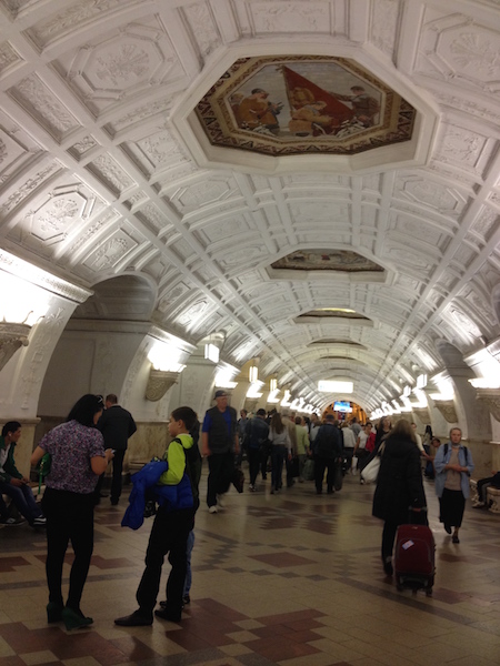
Touring the Top 10 Moscow Metro Stations
By Claudia Looi 2 Comments

Komsomolskaya metro station looks like a museum. It has vaulted ceilings and baroque decor.
Hidden underground, in the heart of Moscow, are historical and architectural treasures of Russia. These are Soviet-era creations – the metro stations of Moscow.
Our guide Maria introduced these elaborate metro stations as “the palaces for the people.” Built between 1937 and 1955, each station holds its own history and stories. Stalin had the idea of building beautiful underground spaces that the masses could enjoy. They would look like museums, art centers, concert halls, palaces and churches. Each would have a different theme. None would be alike.
The two-hour private tour was with a former Intourist tour guide named Maria. Maria lived in Moscow all her life and through the communist era of 60s to 90s. She has been a tour guide for more than 30 years. Being in her 60s, she moved rather quickly for her age. We traveled and crammed with Maria and other Muscovites on the metro to visit 10 different metro stations.

Arrow showing the direction of metro line 1 and 2

Moscow subways are very clean
To Maria, every street, metro and building told a story. I couldn’t keep up with her stories. I don’t remember most of what she said because I was just thrilled being in Moscow. Added to that, she spilled out so many Russian words and names, which to one who can’t read Cyrillic, sounded so foreign and could be easily forgotten.
The metro tour was the first part of our all day tour of Moscow with Maria. Here are the stations we visited:
1. Komsomolskaya Metro Station is the most beautiful of them all. Painted yellow and decorated with chandeliers, gold leaves and semi precious stones, the station looks like a stately museum. And possibly decorated like a palace. I saw Komsomolskaya first, before the rest of the stations upon arrival in Moscow by train from St. Petersburg.
2. Revolution Square Metro Station (Ploshchad Revolyutsii) has marble arches and 72 bronze sculptures designed by Alexey Dushkin. The marble arches are flanked by the bronze sculptures. If you look closely you will see passersby touching the bronze dog's nose. Legend has it that good luck comes to those who touch the dog's nose.

Touch the dog's nose for good luck. At the Revolution Square station

Revolution Square Metro Station
3. Arbatskaya Metro Station served as a shelter during the Soviet-era. It is one of the largest and the deepest metro stations in Moscow.

Arbatskaya Metro Station
4. Biblioteka Imeni Lenina Metro Station was built in 1935 and named after the Russian State Library. It is located near the library and has a big mosaic portrait of Lenin and yellow ceramic tiles on the track walls.

Lenin's portrait at the Biblioteka Imeni Lenina Metro Station

5. Kievskaya Metro Station was one of the first to be completed in Moscow. Named after the capital city of Ukraine by Kiev-born, Nikita Khruschev, Stalin's successor.

Kievskaya Metro Station
6. Novoslobodskaya Metro Station was built in 1952. It has 32 stained glass murals with brass borders.

Novoslobodskaya metro station
7. Kurskaya Metro Station was one of the first few to be built in Moscow in 1938. It has ceiling panels and artwork showing Soviet leadership, Soviet lifestyle and political power. It has a dome with patriotic slogans decorated with red stars representing the Soviet's World War II Hall of Fame. Kurskaya Metro Station is a must-visit station in Moscow.
Ceiling panel and artworks at Kurskaya Metro Station

8. Mayakovskaya Metro Station built in 1938. It was named after Russian poet Vladmir Mayakovsky. This is one of the most beautiful metro stations in the world with 34 mosaics painted by Alexander Deyneka.

Mayakovskaya station

One of the over 30 ceiling mosaics in Mayakovskaya metro station
9. Belorusskaya Metro Station is named after the people of Belarus. In the picture below, there are statues of 3 members of the Partisan Resistance in Belarus during World War II. The statues were sculpted by Sergei Orlov, S. Rabinovich and I. Slonim.

10. Teatralnaya Metro Station (Theatre Metro Station) is located near the Bolshoi Theatre.

Teatralnaya Metro Station decorated with porcelain figures .

Taking the metro's escalator at the end of the tour with Maria the tour guide.
Have you visited the Moscow Metro? Leave your comment below.

January 15, 2017 at 8:17 am
An excellent read! Thanks for much for sharing the Russian metro system with us. We're heading to Moscow in April and exploring the metro stations were on our list and after reading your post, I'm even more excited to go visit them. Thanks again 🙂

December 6, 2017 at 10:45 pm
Hi, do you remember which tour company you contacted for this tour?
Leave a Reply Cancel reply
You must be logged in to post a comment.
Please go to the Instagram Feed settings page to create a feed.
IMAGES
VIDEO
COMMENTS
It involves downloading the map as a PDF and then choosing the appropriate paper size and format. A. Downloading the Map as a PDF. The first step in printing your map is to download the PDF from this page. To do this, simply click on the black "Download" button below the image of the map you wish to print.
Briesemeister projection world map, printable in A4 size, PDF vector format is available as well. The Briesemeister Projection is a modified version of the Hammer projection, where the central meridian is set to 10°E, and the pole is rotated by 45°. The map is also stretched to get a 7:4 width/height ratio instead of the 2:1 of the Hammer.
Welcome to WMB - We Make Better Maps. Explore the world through maps and dive into our extensive collection of map resources. Download your free map as a PDF or image file, get high-resolution vector maps [ coming soon ], teach or learn with map worksheets, and track your travels with our scratch-off wall maps [ coming soon ].
The high-resolution world map below is a two-dimensional (flat) projection of the global landmass and oceans that cover the surface of our spherical planet. The world map shows the continents, oceans, major countries, and a network of lines representing meridians and parallels, the geographic coordinate system. PDF Contents. Download World Maps.
Free Printable Maps in PDF format. More than 794 free printable maps that you can download and print for free. Or, download entire map collections for just $9.00.. Choose from maps of continents, countries, regions (e.g. Central America and the Middle East), and maps of all fifty of the United States, plus the District of Columbia.
Also if you are a travel freak then you can take this digital pdf map along to travel around the world as your guide. Blank World Map Black and White in PDF Some prefer the colored world map format while others prefer going with the black-and-white format. It is purely a matter of personal preference for learning and exploring the world's ...
Printable World Map with Countries Labelled PDF. If you are more interested in learning the world's geography by exploring the country-specific geography then we have the relevant map for you. You can simply go with our printable world map which has all the countries in itself with their labels. PDF.
Apian Globular II world map. PDF world map using Apian Globular II projection. Illustrating oceans, continents and countries. Available in PDF format. Free pdf world maps to download, outline world maps, colouring world maps, physical world maps, political world maps, all on PDF format in A/4 size.
world countries and capitals arc t ic ocean north pacific ocean north atlantic ocean brazil arctic ocean australia pacific ocean united states
These maps are professionally designed and offer a crisp and clear image. These maps can be downloaded and printed in A4, A3 and many other sizes. These maps can be used for any design project and have excellent print quality. In addition, the high-quality printable world maps can also be saved on a device for use at any time.
Get labeled and blank printable world maps with countries like India, USA, Australia, Canada, UK; from all continents : Asia, America, Europe, Africa. ... mountain maps (demonstrates name, area, and stature of mountains and slopes), Similarly travel maps, mainland's, ... PDF. A world map showing major cities is an invaluable resource for ...
World Map Printable. Printable World Maps are available in two catagories: Colored World Political Map and Blank World Map. These maps can be printed in three sizes: Half A4 (14.8 cm x 21 cm), A4 (21 cm x 29.7 cm), and A3 (29.7 cm x 42 cm). Select a map size of your choice that serves the purpose.
What is a high-resolution world map? This high-resolution world map PDF is at 300 dpi with a large-scale dimension of 7000 × 3500 pixels. You can use this map for any purpose, provided you reference this page. ... This high resolution world map shows the countries of the world and their borders in great detail. It is a great reference tool for ...
You can get these maps for your own and use them in your academics or in the general use of going through the extensive world's geography. We believe that our printable maps will facilitate the smooth learning of the world's geography for all the aspirants here. Europe Rivers Map. Blank Map of Serbia. Labeled Map of Japan.
WORLD MAP. The World Map sums up all the contents of mTm on a Google Topographic based map. It is always suggested, especially when you are planning a trip with your own transport, to check on this map the altimetry of your route.
Contributor. Internet Archive. Language. English. 312 pages : 32 cm. Highly detailed maps give balanced worldwide coverage, illustrated thematic pages and thousands of facts and statistics include world and continental ranking tables. Map on lining papers. Includes index. World -- Europe -- Asia -- Africa -- Oceania -- North America -- South ...
PDF. A world map can help you to get good information about the world. The world map that we are coming up with will be a three-dimensional portrayal of the earth. ... Outline Map of World PDF. When we travel abroad, the first thing is that we have to plan which country we should visit, therefore to help you guys to choose a good place we have ...
Commissioning the WTM Global Travel Report supports our commitment to providing attendees to World Travel Market with the latest trends shaping the travel landscape. Using an expansive data-bank covering more than 185 countries worldwide as destinations and as origin markets, covering all major bilateral tourism flows in
Similarly, travel maps, continents, country boundaries and many other theme maps have been made available. World maps are essentially physical or political. The political world map shows different ...
wagon map eng 150110-out. Title. wagon_map_eng_150110-out. Created Date. 1/11/2015 9:54:38 PM.
www.RussianMetro.ru Relevant map during 2013 year. Sheremetyevo international airport You can get to the airport by the bus from Planernaya (bus №817) and Rechnoy vokzal (bus № 851) stations or by the «AirExpress» from the Belorusskaya station. Map of Moscow metro Butovskaya Symbols Station of metro Station with the transition to another line
During the Second World War the metro itself became a strategic asset: it was turned into the city's biggest bomb-shelter and one of the stations even became a library. 217 children were born here in 1941-1942! The metro is the most effective means of transport in the capital.
6. Novoslobodskaya Metro Station was built in 1952. It has 32 stained glass murals with brass borders. Novoslobodskaya metro station. 7. Kurskaya Metro Station was one of the first few to be built in Moscow in 1938. It has ceiling panels and artwork showing Soviet leadership, Soviet lifestyle and political power.